IMAGES TAKEN NEAR TO
Moorland Road, STOKE-ON-TRENT, ST6 1DJ
Introduction
This page details the photographs taken nearby to Moorland Road, ST6 1DJ by members of the Geograph project.
The Geograph project started in 2005 with the aim of publishing, organising and preserving representative images for every square kilometre of Great Britain, Ireland and the Isle of Man.

There are currently over 7.5m images from over14,400 individuals and you can help contribute to the project by visiting https://www.geograph.org.uk
Image Map
Images are licensed for reuse under creativecommons.org/licenses/by-sa/2.0
Notes
- Clicking on the map will re-center to the selected point.
- The higher the marker number, the further away the image location is from the centre of the postcode.
Image Listing (81 Images Found)
Images are licensed for reuse under creativecommons.org/licenses/by-sa/2.0
Image
Details
Distance
1
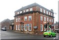
Atlas Figures (Sculpture ) at Burslem Town Hall
Location: On the clock tower of the Old Town Hall, Market Place, Burslem
Installed: 1854-57
Commissioned by: Burslem Urban District Council
Architect: George Thomas Robinson
The clock tower on the Old Town Hall is supported by eight identical Atlas figures, two on each corner. The figures have naked torsos, their lower body and legs have been replaced by a large scroll-like feature, their arms reach up over their heads to support the bell tower. The town hall has been described has having a, 'Bulgy clock tower [with] lofty caryatids in a forest of muscular elbows.'
The Old Town Hall can be seen on the following picture:- http://www.geograph.org.uk/photo/272797
Image: © Steven Birks
Taken: Unknown
0.03 miles
2
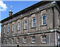
Burslem - old town hall on Market Place
Now part of the Ceramica Museum.
Image: © Dave Bevis
Taken: 2 May 2011
0.04 miles
4
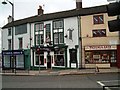
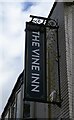
The Post Office Vaults Public house, Burslem
Corner of Market Place and Swan Square
Image: © Steven Birks
Taken: 2 Mar 2001
0.05 miles

8
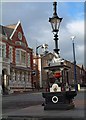
Fountain Square, Burslem
The layout of central Burslem today still has the street plan of a medieval market town. The area of St. John's Square can be seen on a 1720 map. A traditional Victorian drinking fountain in Fountain Square (top of St. John's Square), Burslem. Commissioned by Mayor James Maddock and installed in 1881-83
The building to the left is the National Westminster Bank (was Manchester and Liverpool District Bank). The bank sits on the corner of Fountain Square (was Fountain Place)
Image: © Steven Birks
Taken: 11 Feb 2006
0.06 miles
9
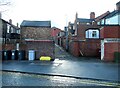
Back alley between Jenkins Street and Nicholas Street
Image: © Steve Daniels
Taken: 10 Apr 2023
0.07 miles