IMAGES TAKEN NEAR TO
Hamil Road, STOKE-ON-TRENT, ST6 1AQ
Introduction
This page details the photographs taken nearby to Hamil Road, ST6 1AQ by members of the Geograph project.
The Geograph project started in 2005 with the aim of publishing, organising and preserving representative images for every square kilometre of Great Britain, Ireland and the Isle of Man.

There are currently over 7.5m images from over14,400 individuals and you can help contribute to the project by visiting https://www.geograph.org.uk
Image Map
Images are licensed for reuse under creativecommons.org/licenses/by-sa/2.0
Notes
- Clicking on the map will re-center to the selected point.
- The higher the marker number, the further away the image location is from the centre of the postcode.
Image Listing (58 Images Found)
Images are licensed for reuse under creativecommons.org/licenses/by-sa/2.0
Image
Details
Distance
1
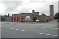
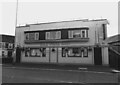
Burslem fire station
Burslem fire station, Hamil Road, Burslem, Staffordshire.
Image: © Kevin Hale
Taken: 21 Oct 2006
0.02 miles
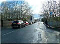
4
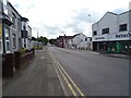
Back alley between Jenkins Street and Nicholas Street
Image: © Steve Daniels
Taken: 10 Apr 2023
0.05 miles
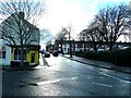
5
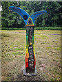
National Cycle Network Route 5 Sign Post, Potteries Loop Line
1000 Millennium cast iron mileposts were funded by the Royal Bank of Scotland to mark the creation of the National Cycle Network, and found along the cycles routes through the UK.
Image: © Brian Deegan
Taken: 20 Jun 2021
0.06 miles

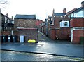
10
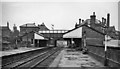
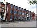
Burslem Station
View SE, towards Etruria and Stoke-on-Trent; ex-North Stafford 'Loop Line', (Stoke) - Etruria - Hanley - Burslem - Tunstall - Kidsgrove. The station closed to passengers when local services were withdrawn on 2/3/64, the loop remaining as a diversionary route until 3/1/66, when goods traffic at Burslem ceased with the closure of the route.
Image: © Ben Brooksbank
Taken: 3 Aug 1962
0.08 miles