IMAGES TAKEN NEAR TO
St. Michaels Road, NEWCASTLE, ST5 9LP
Introduction
This page details the photographs taken nearby to St. Michaels Road, ST5 9LP by members of the Geograph project.
The Geograph project started in 2005 with the aim of publishing, organising and preserving representative images for every square kilometre of Great Britain, Ireland and the Isle of Man.

There are currently over 7.5m images from over14,400 individuals and you can help contribute to the project by visiting https://www.geograph.org.uk
Image Map (Loading...)


Getting Data...Please wait
Leaflet Map data © OpenStreetMap
Images are licensed for reuse under creativecommons.org/licenses/by-sa/2.0
Notes
- Clicking on the map will re-center to the selected point.
- The higher the marker number, the further away the image location is from the centre of the postcode.
Image Listing (51 Images Found)
Images are licensed for reuse under creativecommons.org/licenses/by-sa/2.0
Image
Details
Distance
1
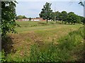
Hempstalls Primary School
Seen across the Lyme Brook, hidden among vegetation at the bottom of the gully.
Image: © Derek Harper
Taken: 30 Jun 2006
0.07 miles
2
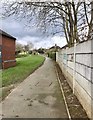
Newcastle-under-Lyme: footpath in a housing estate
The Lyme Brook is just out of shot to the left, see http://www.geograph.org.uk/photo/5312897
Image: © Jonathan Hutchins
Taken: 12 Mar 2017
0.07 miles
3
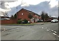
Newcastle-under-Lyme: junction of Brackenberry and Honeywood
Image: © Jonathan Hutchins
Taken: 12 Mar 2017
0.08 miles
4
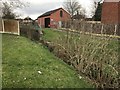
Newcastle-under-Lyme: Lyme Brook in a housing estate
Image: © Jonathan Hutchins
Taken: 12 Mar 2017
0.09 miles
5
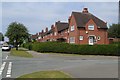
St Michael's Road, Cross Heath
The junction with Collard Avenue (right). In about 170 metres, the road meets the main A34 Liverpool Road.
Image: © Derek Harper
Taken: 30 Jun 2006
0.09 miles
6
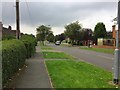
Newcastle-under-Lyme: St Michael's Road
Image: © Jonathan Hutchins
Taken: 21 Sep 2016
0.10 miles
7
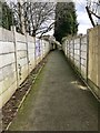
Newcastle-under-Lyme: fenced footpath in a housing estate
This is a public footpath, Newcastle FP 132, which runs between Liverpool Road and Station Walks.
Image: © Jonathan Hutchins
Taken: 12 Mar 2017
0.10 miles
8
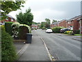
Honeywood, Newcastle-under-Lyme
Looking south east.
Image: © JThomas
Taken: 11 Jun 2016
0.10 miles
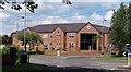
9
Newcastle-under-Lyme: Hempstalls Hall Care Home
This care home opened in February 2010, on the site of a pub called The Hempstalls which is seen here during demolition a year previously http://thepeoplesarchive.co.uk/image/newcastle/hempstalls-inn-2009
Image: © Jonathan Hutchins
Taken: 21 Sep 2016
0.11 miles
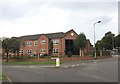
10
Hempstalls Hall, Newcastle under Lyme
A care home that replaced Hempstalls Inn, (demolished early 2009). Providing residential care for the elderly, specialising in Alzheimer's
A photo of the Inn being demolished: http://thepeoplesarchive.co.uk/image/newcastle/hempstalls-inn-2009
Image: © Carl Farnell
Taken: 20 Jun 2011
0.11 miles