IMAGES TAKEN NEAR TO
Milehouse Lane, NEWCASTLE, ST5 9JR
Introduction
This page details the photographs taken nearby to Milehouse Lane, ST5 9JR by members of the Geograph project.
The Geograph project started in 2005 with the aim of publishing, organising and preserving representative images for every square kilometre of Great Britain, Ireland and the Isle of Man.

There are currently over 7.5m images from over14,400 individuals and you can help contribute to the project by visiting https://www.geograph.org.uk
Image Map
Images are licensed for reuse under creativecommons.org/licenses/by-sa/2.0
Notes
- Clicking on the map will re-center to the selected point.
- The higher the marker number, the further away the image location is from the centre of the postcode.
Image Listing (6 Images Found)
Images are licensed for reuse under creativecommons.org/licenses/by-sa/2.0
Image
Details
Distance
4
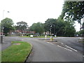
Roundabout on Hoon Avenue
Junction with the B5368.
Image: © JThomas
Taken: 11 Jun 2016
0.17 miles
5

Hoon Avenue
Looking north near Merryfields School.
Image: © JThomas
Taken: 11 Jun 2016
0.23 miles
6
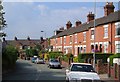
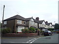
Silverdale Road, Wolstanton
A straight red brick terrace beside a curving road, the B5368, a little west of the High Street.
Image: © Derek Harper
Taken: 30 Jun 2006
0.24 miles