IMAGES TAKEN NEAR TO
Dimsdale Hall Drive, NEWCASTLE, ST5 9DZ
Introduction
This page details the photographs taken nearby to Dimsdale Hall Drive, ST5 9DZ by members of the Geograph project.
The Geograph project started in 2005 with the aim of publishing, organising and preserving representative images for every square kilometre of Great Britain, Ireland and the Isle of Man.

There are currently over 7.5m images from over14,400 individuals and you can help contribute to the project by visiting https://www.geograph.org.uk
Image Map
Images are licensed for reuse under creativecommons.org/licenses/by-sa/2.0
Notes
- Clicking on the map will re-center to the selected point.
- The higher the marker number, the further away the image location is from the centre of the postcode.
Image Listing (28 Images Found)
Images are licensed for reuse under creativecommons.org/licenses/by-sa/2.0
Image
Details
Distance
1
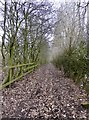
Public footpath bisecting Wolstanton Golf Course
Image: © Jonathan Hutchins
Taken: 21 Feb 2018
0.07 miles
2
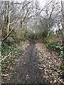
Public footpath bisecting Wolstanton Golf Course
Image: © Jonathan Hutchins
Taken: 21 Feb 2018
0.10 miles
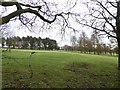
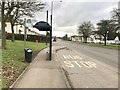
4

Crocuses on a grassy bank by the A34
Image: © Jonathan Hutchins
Taken: 21 Feb 2018
0.13 miles
5
Crocuses on a grassy bank by the A34
Image: © Jonathan Hutchins
Taken: 21 Feb 2018
0.14 miles
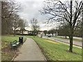
7
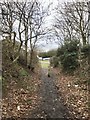
Footpath leading off A34
Looking back to the viewpoint by the road, see https://www.geograph.org.uk/photo/5690247
Image: © Jonathan Hutchins
Taken: 21 Feb 2018
0.15 miles

10

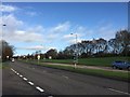
Newcastle-Under-Lyme : Liverpool Road A34
Looking along Liverpool Road.
Image: © Lewis Clarke
Taken: 23 Sep 2019
0.15 miles