IMAGES TAKEN NEAR TO
Lower Milehouse Lane, NEWCASTLE, ST5 9BT
Introduction
This page details the photographs taken nearby to Lower Milehouse Lane, ST5 9BT by members of the Geograph project.
The Geograph project started in 2005 with the aim of publishing, organising and preserving representative images for every square kilometre of Great Britain, Ireland and the Isle of Man.

There are currently over 7.5m images from over14,400 individuals and you can help contribute to the project by visiting https://www.geograph.org.uk
Image Map (4 Images)


Getting Data...Please wait
Leaflet Map data © OpenStreetMap
Images are licensed for reuse under creativecommons.org/licenses/by-sa/2.0
Notes
- Clicking on the map will re-center to the selected point.
- The higher the marker number, the further away the image location is from the centre of the postcode.
Image Listing (4 Images Found)
Images are licensed for reuse under creativecommons.org/licenses/by-sa/2.0
Image
Details
Distance
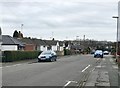
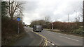
1
Newcastle-under-Lyme: crossroads in Cross Heath
Image: © Jonathan Hutchins
Taken: 6 Jun 2016
0.23 miles
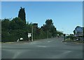
2
Brymbo Road, Holditch
At the start of the 20th century a canal ran through fields here. Then there was a colliery and now a large industrial estate. This is the distribution road leading off from the A34.
Image: © Richard Webb
Taken: 17 Mar 2022
0.23 miles
3
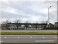
Allied Bakeries Stoke
On the west side of the A34 north of Newcastle-under-Lyme.
Image: © Jonathan Hutchins
Taken: 21 Feb 2018
0.25 miles