IMAGES TAKEN NEAR TO
Johnson Avenue, NEWCASTLE, ST5 9AG
Introduction
This page details the photographs taken nearby to Johnson Avenue, ST5 9AG by members of the Geograph project.
The Geograph project started in 2005 with the aim of publishing, organising and preserving representative images for every square kilometre of Great Britain, Ireland and the Isle of Man.

There are currently over 7.5m images from over14,400 individuals and you can help contribute to the project by visiting https://www.geograph.org.uk
Image Map (Loading...)


Getting Data...Please wait
Leaflet Map data © OpenStreetMap
Images are licensed for reuse under creativecommons.org/licenses/by-sa/2.0
Notes
- Clicking on the map will re-center to the selected point.
- The higher the marker number, the further away the image location is from the centre of the postcode.
Image Listing (26 Images Found)
Images are licensed for reuse under creativecommons.org/licenses/by-sa/2.0
Image
Details
Distance
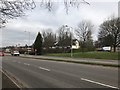
1
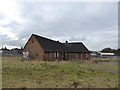
Derelict building in field by A34
Image: © Jonathan Hutchins
Taken: 21 Feb 2018
0.04 miles
2
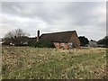
Derelict building in field by A34
Image: © Jonathan Hutchins
Taken: 21 Feb 2018
0.04 miles
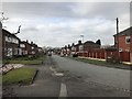
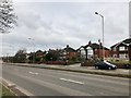
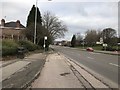
6
A34 north of Newcastle-under-Lyme
Image: © Jonathan Hutchins
Taken: 21 Feb 2018
0.09 miles
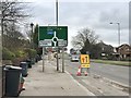
7
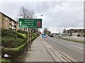
Hospital sign on the A34
The hospital Trust is now the 'University Hospitals of North Midlands' following the merger of Stoke and Stafford hospitals.
Image: © Jonathan Hutchins
Taken: 21 Feb 2018
0.10 miles
8
A34 north of Newcastle-under-Lyme
Image: © Jonathan Hutchins
Taken: 21 Feb 2018
0.10 miles
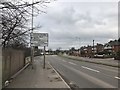
10
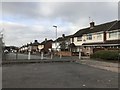
Lovatt Avenue
At some point Lovatt Avenue evidently gave onto the main A34.
Image: © Jonathan Hutchins
Taken: 21 Feb 2018
0.10 miles