IMAGES TAKEN NEAR TO
Clayhanger Close, NEWCASTLE, ST5 8TF
Introduction
This page details the photographs taken nearby to Clayhanger Close, ST5 8TF by members of the Geograph project.
The Geograph project started in 2005 with the aim of publishing, organising and preserving representative images for every square kilometre of Great Britain, Ireland and the Isle of Man.

There are currently over 7.5m images from over14,400 individuals and you can help contribute to the project by visiting https://www.geograph.org.uk
Image Map
Images are licensed for reuse under creativecommons.org/licenses/by-sa/2.0
Notes
- Clicking on the map will re-center to the selected point.
- The higher the marker number, the further away the image location is from the centre of the postcode.
Image Listing (3 Images Found)
Images are licensed for reuse under creativecommons.org/licenses/by-sa/2.0
Image
Details
Distance
1
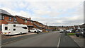
Old Hall Drive
New houses near Bradwall Hall.
Image: © Richard Webb
Taken: 17 Mar 2022
0.09 miles
2
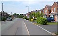
Chatterley Close, Bradwell
This road on a hilltop is very wide, making parking easy - probably popular with driving schools, too.
Image: © Derek Harper
Taken: 30 Jun 2006
0.14 miles
3
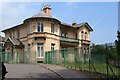
Bradwell Lodge
The early C19 house with its distinctive circular southern corner, is described at http://www.britishlistedbuildings.co.uk/en-385906-bradwell-lodge-newcastle-under-lyme . When this photo was taken, it housed Wolstanton Library on the first floor; it is now a Community Centre.
Image: © Derek Harper
Taken: 30 Jun 2006
0.25 miles