IMAGES TAKEN NEAR TO
Hanbridge Avenue, NEWCASTLE, ST5 8HJ
Introduction
This page details the photographs taken nearby to Hanbridge Avenue, ST5 8HJ by members of the Geograph project.
The Geograph project started in 2005 with the aim of publishing, organising and preserving representative images for every square kilometre of Great Britain, Ireland and the Isle of Man.

There are currently over 7.5m images from over14,400 individuals and you can help contribute to the project by visiting https://www.geograph.org.uk
Image Map (Loading...)


Getting Data...Please wait
Leaflet Map data © OpenStreetMap
Images are licensed for reuse under creativecommons.org/licenses/by-sa/2.0
Notes
- Clicking on the map will re-center to the selected point.
- The higher the marker number, the further away the image location is from the centre of the postcode.
Image Listing (10 Images Found)
Images are licensed for reuse under creativecommons.org/licenses/by-sa/2.0
Image
Details
Distance
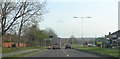
3
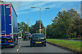
Newcastle-Under-Lyme : Talke Road A34
Heading along Talke Road.
Image: © Lewis Clarke
Taken: 23 Sep 2019
0.17 miles
4
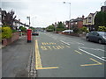
Bus stop and George V postbox on Dimsdale Parade West
Postbox No. ST5 412.
See Image] for postbox.
Image: © JThomas
Taken: 11 Jun 2016
0.18 miles
5
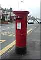
George V postbox on Dimsdale Parade West
Postbox No. ST5 412.
See Image] for context.
Image: © JThomas
Taken: 11 Jun 2016
0.18 miles
7
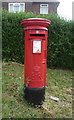
Elizabeth II postbox on Wolstanton Road
Postbox No. ST5 585.
See Image] for context.
Image: © JThomas
Taken: 11 Jun 2016
0.23 miles
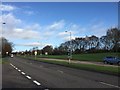
8
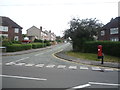
Junction of Wolstanton Road with Bamber Place
Showing position of Postbox No. ST5 585.
See Image] for postbox.
Image: © JThomas
Taken: 11 Jun 2016
0.23 miles