IMAGES TAKEN NEAR TO
Talke Road, NEWCASTLE, ST5 7NL
Introduction
This page details the photographs taken nearby to Talke Road, ST5 7NL by members of the Geograph project.
The Geograph project started in 2005 with the aim of publishing, organising and preserving representative images for every square kilometre of Great Britain, Ireland and the Isle of Man.

There are currently over 7.5m images from over14,400 individuals and you can help contribute to the project by visiting https://www.geograph.org.uk
Image Map (Loading...)


Getting Data...Please wait
Leaflet Map data © OpenStreetMap
Images are licensed for reuse under creativecommons.org/licenses/by-sa/2.0
Notes
- Clicking on the map will re-center to the selected point.
- The higher the marker number, the further away the image location is from the centre of the postcode.
Image Listing (10 Images Found)
Images are licensed for reuse under creativecommons.org/licenses/by-sa/2.0
Image
Details
Distance
1
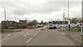
Bradwell Lane
Where it meets Talke Road (A34)
Image: © Richard Webb
Taken: 17 Mar 2022
0.07 miles
2

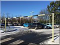
Second Hand Van Sales and Car Body Repair Shop
Image: © Anthony Parkes
Taken: 11 Apr 2014
0.09 miles

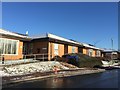
4
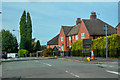
Newcastle-Under-Lyme : Beasley Avenue
Looking along Beasley Avenue off Talke Road.
Image: © Lewis Clarke
Taken: 23 Sep 2019
0.09 miles
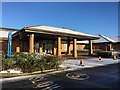
6
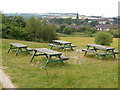
Picnic site near Chesterton
Holy Trinity church in Chesterton is a landmark from this picnic site on open land between the Parkouse Industrial Estate and Beasley, north of Newcastle.
Image: © Derek Harper
Taken: 30 Jun 2006
0.18 miles
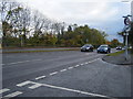
10
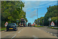
Newcastle-Under-Lyme : Talke Road A34
Looking along Talke Road.
Image: © Lewis Clarke
Taken: 23 Sep 2019
0.21 miles