IMAGES TAKEN NEAR TO
Mount Pleasant, NEWCASTLE, ST5 7LQ
Introduction
This page details the photographs taken nearby to Mount Pleasant, ST5 7LQ by members of the Geograph project.
The Geograph project started in 2005 with the aim of publishing, organising and preserving representative images for every square kilometre of Great Britain, Ireland and the Isle of Man.

There are currently over 7.5m images from over14,400 individuals and you can help contribute to the project by visiting https://www.geograph.org.uk
Image Map (Loading...)


Getting Data...Please wait
Leaflet Map data © OpenStreetMap
Images are licensed for reuse under creativecommons.org/licenses/by-sa/2.0
Notes
- Clicking on the map will re-center to the selected point.
- The higher the marker number, the further away the image location is from the centre of the postcode.
Image Listing (11 Images Found)
Images are licensed for reuse under creativecommons.org/licenses/by-sa/2.0
Image
Details
Distance
1

Chesterton School From Apedale Country Park
Image: © Richard Styles
Taken: 25 Feb 2005
0.11 miles
2
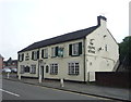
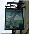
The Grove House public house
On London Road.
Image: © JThomas
Taken: 11 Jun 2016
0.20 miles
3
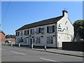
The Grove House, Chesterton
A pub on London Road. England flags are out, since the Football World Cup is in progress.
Image: © David Weston
Taken: 5 Jul 2018
0.20 miles

6
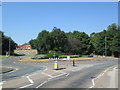
Roundabout at Chesterton
Viewed from Wolstanton Road.
Image: © David Weston
Taken: 5 Jul 2018
0.21 miles
7
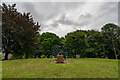
Pit Wheel Monument, Chesterton Memorial Gardens
Erected 1995 to :-
Harold Cork
And all the men who worked
and those who died at
Holditch Colliery (1912-1989)
Image: © Brian Deegan
Taken: 7 Aug 2021
0.22 miles

9

St John the Evangelist, Broad Meadow
A rather small Catholic Church of unusual shape with, to the right, the much larger Parish Hall.
Image: © Steve Lewin
Taken: 11 Apr 2007
0.22 miles
10
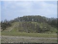
Disused Tip
One of many disused mining spoil tips in this area. This one is on private land but that doesn't seem to have stopped off-road bikers from tearing up a fair amount of the planting.
Image: © Steve Lewin
Taken: 7 Apr 2007
0.23 miles