IMAGES TAKEN NEAR TO
School Street, NEWCASTLE, ST5 7HY
Introduction
This page details the photographs taken nearby to School Street, ST5 7HY by members of the Geograph project.
The Geograph project started in 2005 with the aim of publishing, organising and preserving representative images for every square kilometre of Great Britain, Ireland and the Isle of Man.

There are currently over 7.5m images from over14,400 individuals and you can help contribute to the project by visiting https://www.geograph.org.uk
Image Map (Loading...)


Getting Data...Please wait
Leaflet Map data © OpenStreetMap
Images are licensed for reuse under creativecommons.org/licenses/by-sa/2.0
Notes
- Clicking on the map will re-center to the selected point.
- The higher the marker number, the further away the image location is from the centre of the postcode.
Image Listing (16 Images Found)
Images are licensed for reuse under creativecommons.org/licenses/by-sa/2.0
Image
Details
Distance

3
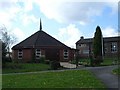
St John the Evangelist, Broad Meadow
A rather small Catholic Church of unusual shape with, to the right, the much larger Parish Hall.
Image: © Steve Lewin
Taken: 11 Apr 2007
0.11 miles
4
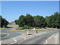
Roundabout at Chesterton
Viewed from Wolstanton Road.
Image: © David Weston
Taken: 5 Jul 2018
0.11 miles

8
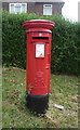
Elizabeth II postbox on Wolstanton Road
Postbox No. ST5 585.
See Image] for context.
Image: © JThomas
Taken: 11 Jun 2016
0.15 miles
9
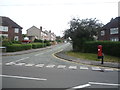
Junction of Wolstanton Road with Bamber Place
Showing position of Postbox No. ST5 585.
See Image] for postbox.
Image: © JThomas
Taken: 11 Jun 2016
0.15 miles