IMAGES TAKEN NEAR TO
Birch House Road, NEWCASTLE, ST5 7HB
Introduction
This page details the photographs taken nearby to Birch House Road, ST5 7HB by members of the Geograph project.
The Geograph project started in 2005 with the aim of publishing, organising and preserving representative images for every square kilometre of Great Britain, Ireland and the Isle of Man.

There are currently over 7.5m images from over14,400 individuals and you can help contribute to the project by visiting https://www.geograph.org.uk
Image Map (Loading...)


Getting Data...Please wait
Leaflet Map data © OpenStreetMap
Images are licensed for reuse under creativecommons.org/licenses/by-sa/2.0
Notes
- Clicking on the map will re-center to the selected point.
- The higher the marker number, the further away the image location is from the centre of the postcode.
Image Listing (7 Images Found)
Images are licensed for reuse under creativecommons.org/licenses/by-sa/2.0
Image
Details
Distance
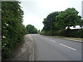
1
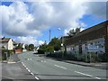
Crackley Community Centre
Crackley is one of many old miners estates in this area.
Image: © Steve Lewin
Taken: 7 Sep 2006
0.11 miles
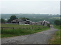
4
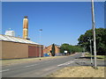
Factory in Chesterton
Ibstock, a brick manufacturer, near the junction of Cross Street and Audley Road.
Image: © David Weston
Taken: 5 Jul 2018
0.20 miles
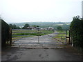
5
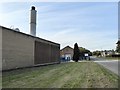
Chesterton: entrance to Ibstock Bricks
There has been a brickworks on this site since the 1830s. A detailed history of the company may be found at:
http://www.ibstock.com/history/
Image: © Jonathan Hutchins
Taken: 15 Oct 2016
0.21 miles