IMAGES TAKEN NEAR TO
Crackley Bank, NEWCASTLE, ST5 7AB
Introduction
This page details the photographs taken nearby to Crackley Bank, ST5 7AB by members of the Geograph project.
The Geograph project started in 2005 with the aim of publishing, organising and preserving representative images for every square kilometre of Great Britain, Ireland and the Isle of Man.

There are currently over 7.5m images from over14,400 individuals and you can help contribute to the project by visiting https://www.geograph.org.uk
Image Map (Loading...)


Getting Data...Please wait
Leaflet Map data © OpenStreetMap
Images are licensed for reuse under creativecommons.org/licenses/by-sa/2.0
Notes
- Clicking on the map will re-center to the selected point.
- The higher the marker number, the further away the image location is from the centre of the postcode.
Image Listing (6 Images Found)
Images are licensed for reuse under creativecommons.org/licenses/by-sa/2.0
Image
Details
Distance
2
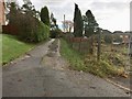
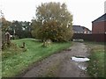
Newcastle-under-Lyme: lane and footpath off Crackley Bank
This runs alongside the vacant lot seen in http://www.geograph.org.uk/photo/5197412
Image: © Jonathan Hutchins
Taken: 13 Nov 2016
0.21 miles
3
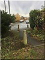
Newcastle-under-Lyme: Newport Grove
Viewed from the footpath seen in http://www.geograph.org.uk/photo/5197421
Image: © Jonathan Hutchins
Taken: 13 Nov 2016
0.21 miles
4
Newcastle-under-Lyme: lane and footpath off Crackley Bank
Over the fencing on the left is the vacant lot seen in http://www.geograph.org.uk/photo/5197412
Image: © Jonathan Hutchins
Taken: 13 Nov 2016
0.21 miles
5
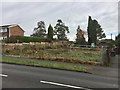
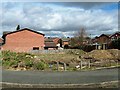
Newcastle-under-Lyme: vacant lot on Crackley Bank
Image: © Jonathan Hutchins
Taken: 13 Nov 2016
0.22 miles
6
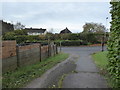
Newcastle-under-Lyme: lane and footpath through suburb
Image: © Jonathan Hutchins
Taken: 13 Nov 2016
0.22 miles