IMAGES TAKEN NEAR TO
Allman Row, NEWCASTLE, ST5 6SD
Introduction
This page details the photographs taken nearby to Allman Row, ST5 6SD by members of the Geograph project.
The Geograph project started in 2005 with the aim of publishing, organising and preserving representative images for every square kilometre of Great Britain, Ireland and the Isle of Man.

There are currently over 7.5m images from over14,400 individuals and you can help contribute to the project by visiting https://www.geograph.org.uk
Image Map
Images are licensed for reuse under creativecommons.org/licenses/by-sa/2.0
Notes
- Clicking on the map will re-center to the selected point.
- The higher the marker number, the further away the image location is from the centre of the postcode.
Image Listing (53 Images Found)
Images are licensed for reuse under creativecommons.org/licenses/by-sa/2.0
Image
Details
Distance
1
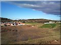
New housing, and more to come!
The Silverdale Colliery site having been cleared, the first phase of new houses is complete, and in the foreground the ground has been cleared ready for the next phase. The development is called 'Heritage Park'. In the right background are the roofs of the Silverdale Enterprise Park, while out of shot to the right the ground rises to a ridge overlooking 'The Void', a former open-cast site including a large lake now owned by the Land Trust and managed as a Country Park (see e.g. Image)
Image: © Jonathan Hutchins
Taken: 10 Apr 2012
0.06 miles
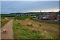
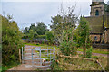
2
Silverdale : Footpath
A footpath heads alongside the parish of Silverdale.
Image: © Lewis Clarke
Taken: 22 Sep 2019
0.07 miles
3
Silverdale : Footpath
A footpath heads down into the settlement.
Image: © Lewis Clarke
Taken: 22 Sep 2019
0.07 miles
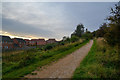
4
Silverdale : Footpath
A footpath along the former Stoke-Market Drayton Line.
Image: © Lewis Clarke
Taken: 22 Sep 2019
0.11 miles
5
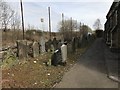
Gravestones behind St Luke's, Silverdale
Behind the chainlink fence is a metalled public footpath, formerly the railway line between Newcastle and Market Drayton.
Image: © Jonathan Hutchins
Taken: 6 Apr 2018
0.12 miles
6

Silverdale : Silverdale Scenery
Looking down to a housing estate.
Image: © Lewis Clarke
Taken: 22 Sep 2019
0.12 miles
7
Silverdale : Footpath
Heading down onto the Former Stoke-Market Drayton Line.
Image: © Lewis Clarke
Taken: 22 Sep 2019
0.12 miles
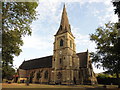
9

St Luke's Church, Silverdale from Gorsty Bank
Image: © Jonathan Hutchins
Taken: 3 Mar 2018
0.12 miles
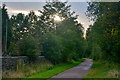
10
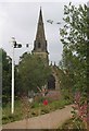
Signal & St Luke's
The Railway in Silverdale is now a cycle path. The Church is St Luke the Evangelist.
Image: © Glyn Baker
Taken: 4 Sep 2011
0.12 miles