IMAGES TAKEN NEAR TO
The Brighton, NEWCASTLE, ST5 6JR
Introduction
This page details the photographs taken nearby to The Brighton, ST5 6JR by members of the Geograph project.
The Geograph project started in 2005 with the aim of publishing, organising and preserving representative images for every square kilometre of Great Britain, Ireland and the Isle of Man.

There are currently over 7.5m images from over14,400 individuals and you can help contribute to the project by visiting https://www.geograph.org.uk
Image Map
Images are licensed for reuse under creativecommons.org/licenses/by-sa/2.0
Notes
- Clicking on the map will re-center to the selected point.
- The higher the marker number, the further away the image location is from the centre of the postcode.
Image Listing (53 Images Found)
Images are licensed for reuse under creativecommons.org/licenses/by-sa/2.0
Image
Details
Distance
1
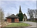
St Luke's, Silverdale from the car park
The church is Grade II listed, see https://www.historicengland.org.uk/listing/the-list/list-entry/1291424
Image: © Jonathan Hutchins
Taken: 6 Apr 2018
0.04 miles
2
St Luke's Church, Silverdale
Taken from just across the old railway line, now a footpath. The fencing indicates the whole area of the old colliery, which is earmarked for housing development
Image: © Jonathan Hutchins
Taken: 17 Aug 2011
0.05 miles
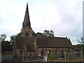
3
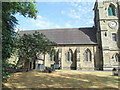
St. Luke the Evangelist Church, Silverdale, Newcastle
Parish Church. 1853. By R. Armstrong. Coursed and squared
rubble with plain tiled roof with scalloped bands. Decorated
style. SE tower and spire, nave and 2 aisles, chancel.
Buttressed tower of 3 stages with paired lights in lower
stage, clock above, and paired bell-chamber lights. Corbel
table, octagonal brooch spire. Polygonal stair-turret in SE
angle. South aisle porch, buttressed and with coped gable over
simple chamfered archway. Buttresses divide aisle walls into
bays, with 2-light Decorated windows. West door in ogee arch
with heavy mouldings, and 3-light window over. East window to
chancel of 4-lights.
INTERIOR: 5-bay Early English style arcades with alternate
cylindrical and octagonal shafts. Raking trusses carry collars
with queen struts to wind-braced roof. Simple moulded chancel
arch. Encaustic tiles, possibly by Minton to chancel, which
contains Stanier memorial, a large wall tablet erected in 1856
with bust beneath wide ogee arch flanked by pinnacles, the
whole enriched with niches, crockets and foliate decoration.
Stained glass: badly corroded representation of Life of Christ
in east window, undated. Figures of Saints in north and south
aisles, 1892 and 1897. Original oak pews. Chancel screen with
3 traceried arches and cross over, erected as war memorial.
St. Luke >> https://en.wikipedia.org/wiki/Luke_the_Evangelist
Silverdale >> https://en.wikipedia.org/wiki/Silverdale,_Staffordshire
Image: © Brian Deegan
Taken: 3 Dec 2017
0.05 miles
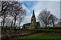
5

St Luke's Church, Silverdale from Gorsty Bank
Image: © Jonathan Hutchins
Taken: 3 Mar 2018
0.05 miles
6
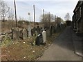
Gravestones behind St Luke's, Silverdale
Behind the chainlink fence is a metalled public footpath, formerly the railway line between Newcastle and Market Drayton.
Image: © Jonathan Hutchins
Taken: 6 Apr 2018
0.05 miles
7
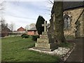
Cadman memorial, St Luke's churchyard, Silverdale
Image: © Jonathan Hutchins
Taken: 6 Apr 2018
0.05 miles
8
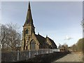
Silverdale: St Luke's Church
Viewed from the former railway line, now a footpath.
Image: © Jonathan Hutchins
Taken: 5 Apr 2009
0.06 miles
9
St Luke's Church, Silverdale
Grade II listed https://www.historicengland.org.uk/listing/the-list/list-entry/1291424
Image: © Jonathan Hutchins
Taken: 6 Apr 2018
0.06 miles
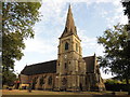
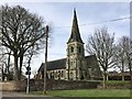
10
St Luke's Church, Silverdale
Viewed from the south.
Image: © David Weston
Taken: 7 Aug 2018
0.06 miles