IMAGES TAKEN NEAR TO
Silverdale Sidings, NEWCASTLE, ST5 6JF
Introduction
This page details the photographs taken nearby to Silverdale Sidings, ST5 6JF by members of the Geograph project.
The Geograph project started in 2005 with the aim of publishing, organising and preserving representative images for every square kilometre of Great Britain, Ireland and the Isle of Man.

There are currently over 7.5m images from over14,400 individuals and you can help contribute to the project by visiting https://www.geograph.org.uk
Image Map
Images are licensed for reuse under creativecommons.org/licenses/by-sa/2.0
Notes
- Clicking on the map will re-center to the selected point.
- The higher the marker number, the further away the image location is from the centre of the postcode.
Image Listing (56 Images Found)
Images are licensed for reuse under creativecommons.org/licenses/by-sa/2.0
Image
Details
Distance
1
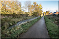
Silverdale Station (Disused)
Silverdale railway station was a railway station that served the village of Silverdale, Staffordshire, England. It was opened by the North Staffordshire Railway in 1863 and closed to passengers in 1964.
Today, only the restored platforms are still in place. The station building has been rebuilt at the Apedale Heritage Centre.
Image: © Brian Deegan
Taken: 10 Nov 2019
0.03 miles
2
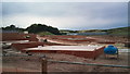
Silverdale: construction of new housing estate
This new development, named 'Heritage Park', is built on the site of the former Silverdale Colliery, closed in 1998. In the centre background are units of Silverdale Enterprise Park, while the land rises to the right to Silverdale Country Park.
Image: © Jonathan Hutchins
Taken: 5 Sep 2010
0.06 miles
4
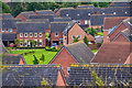
Silverdale : Silverdale Scenery
Looking down to a housing estate.
Image: © Lewis Clarke
Taken: 22 Sep 2019
0.06 miles
6
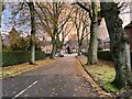
Sneyd Terrace, Silverdale
Looking along Sneyd Terrace from the junction with High Street. The spire of St Luke's Church can be seen behind the trees.
Image: © David Weston
Taken: 7 Aug 2018
0.07 miles
7
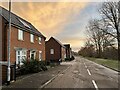
Edge of new housing estate
The whole development occupies the site of Silverdale Colliery, closed 1998.
Image: © Jonathan Hutchins
Taken: 10 Dec 2022
0.08 miles
8
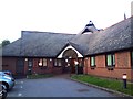
Silverdale: Brighton House care home
Built on the site of an old row of cottages called The Brighton, hence the name.
Image: © Jonathan Hutchins
Taken: 7 Jun 2011
0.08 miles