IMAGES TAKEN NEAR TO
Pennine Way, NEWCASTLE, ST5 6JA
Introduction
This page details the photographs taken nearby to Pennine Way, ST5 6JA by members of the Geograph project.
The Geograph project started in 2005 with the aim of publishing, organising and preserving representative images for every square kilometre of Great Britain, Ireland and the Isle of Man.

There are currently over 7.5m images from over14,400 individuals and you can help contribute to the project by visiting https://www.geograph.org.uk
Image Map (Loading...)


Getting Data...Please wait
Leaflet Map data © OpenStreetMap
Images are licensed for reuse under creativecommons.org/licenses/by-sa/2.0
Notes
- Clicking on the map will re-center to the selected point.
- The higher the marker number, the further away the image location is from the centre of the postcode.
Image Listing (22 Images Found)
Images are licensed for reuse under creativecommons.org/licenses/by-sa/2.0
Image
Details
Distance
1
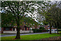
Newcastle-Under-Lyme : Cleveland Road
Cleveland Road with a grassy area alongside it.
Image: © Lewis Clarke
Taken: 22 Sep 2019
0.07 miles
2
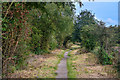
Newcastle-Under-Lyme : Footpath
Looking along a footpath.
Image: © Lewis Clarke
Taken: 22 Sep 2019
0.09 miles

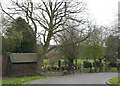
5
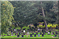
Newcastle-Under-Lyme : Cemetery
Looking across towards a cemetery.
Image: © Lewis Clarke
Taken: 22 Sep 2019
0.13 miles


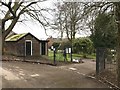
9
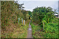
Newcastle-Under-Lyme : Footpath
A footpath heading through Alsagers Bank.
Image: © Lewis Clarke
Taken: 22 Sep 2019
0.15 miles
10
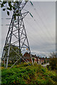
Newcastle-Under-Lyme : Cheviot Close
Looking along Cheviot Close with a pylon in view.
Image: © Lewis Clarke
Taken: 22 Sep 2019
0.16 miles