IMAGES TAKEN NEAR TO
Arthur Street, NEWCASTLE, ST5 6ES
Introduction
This page details the photographs taken nearby to Arthur Street, ST5 6ES by members of the Geograph project.
The Geograph project started in 2005 with the aim of publishing, organising and preserving representative images for every square kilometre of Great Britain, Ireland and the Isle of Man.

There are currently over 7.5m images from over14,400 individuals and you can help contribute to the project by visiting https://www.geograph.org.uk
Image Map
Images are licensed for reuse under creativecommons.org/licenses/by-sa/2.0
Notes
- Clicking on the map will re-center to the selected point.
- The higher the marker number, the further away the image location is from the centre of the postcode.
Image Listing (37 Images Found)
Images are licensed for reuse under creativecommons.org/licenses/by-sa/2.0
Image
Details
Distance
1

Newcastle-Under-Lyme : Arthur Street
Looking along Arthur Street from Knutton Lane.
Image: © Lewis Clarke
Taken: 22 Sep 2019
0.03 miles
2

Newcastle-Under-Lyme : Knutton Lane
Looking along Knutton Lane.
Image: © Lewis Clarke
Taken: 22 Sep 2019
0.06 miles
3
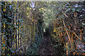
Newcastle-Under-Lyme : Footpath
Looking along a path between Silverdale Road and Knutton Lane.
Image: © Lewis Clarke
Taken: 22 Sep 2019
0.08 miles
4
Newcastle under Lyme - View E from near Knutton Lane Bridge along Greenway
Image: © Colin Park
Taken: 7 Mar 2016
0.10 miles

6

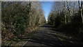
Newcastle-Under-Lyme : Silverdale Road B5044
Looking along Silverdale Road.
Image: © Lewis Clarke
Taken: 22 Sep 2019
0.11 miles
7
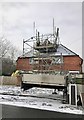
Roofing work on a house in Knutton
Image: © Jonathan Hutchins
Taken: 27 Feb 2018
0.12 miles
8

Silverdale : Footpath
A footpath along the former Pool Dam Branch.
Image: © Lewis Clarke
Taken: 22 Sep 2019
0.13 miles
9
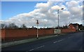
Knutton: site of former pub
A large pub called The Forge Inn was situated on the waste ground behind these neat brick walls, erected soon after its demolition in 2009 http://www.closedpubs.co.uk/staffordshire/newcastleunderlyme_forgeinn.html. Knutton Forge was a huge complex of furnaces and mills, producing large quantities of iron in its heyday, which closed in 1929, leaving only the pub and local memories to perpetuate its name.
Image: © Jonathan Hutchins
Taken: 6 Feb 2015
0.14 miles
10
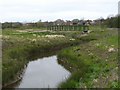
Footbridge over Lyme Brook
There are quite a number of small streams round this area, all known locally as Lyme Brook. Most of them disappear underground fairly often so I suppose it is just possible that they are all the same stream.
Image: © Steve Lewin
Taken: 9 Apr 2007
0.14 miles