IMAGES TAKEN NEAR TO
Walls Wood, NEWCASTLE, ST5 5LD
Introduction
This page details the photographs taken nearby to Walls Wood, ST5 5LD by members of the Geograph project.
The Geograph project started in 2005 with the aim of publishing, organising and preserving representative images for every square kilometre of Great Britain, Ireland and the Isle of Man.

There are currently over 7.5m images from over14,400 individuals and you can help contribute to the project by visiting https://www.geograph.org.uk
Image Map (Loading...)


Getting Data...Please wait
Leaflet Map data © OpenStreetMap
Images are licensed for reuse under creativecommons.org/licenses/by-sa/2.0
Notes
- Clicking on the map will re-center to the selected point.
- The higher the marker number, the further away the image location is from the centre of the postcode.
Image Listing (11 Images Found)
Images are licensed for reuse under creativecommons.org/licenses/by-sa/2.0
Image
Details
Distance
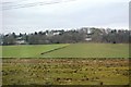
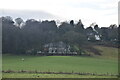
1
Housing development
Houses built on Madeley Park Farm
Image: © charles c
Taken: 5 Sep 2007
0.02 miles

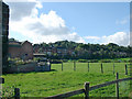
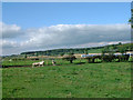
3
Roast Ostrich for Xmas
They are probably pets as I saw only three, former Madeley Park Farm behind.
Image: © charles c
Taken: 5 Sep 2007
0.12 miles
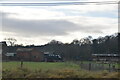
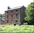
7
Sheep in field & train
Main railway line to Crewe behind.
Image: © charles c
Taken: 5 Sep 2007
0.18 miles
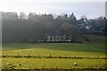
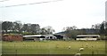
9
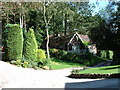
Luxury housing near Baldwins Gate
An estate of expensive houses,a footpath runs somewhere through here but couldn't follow it.
Image: © charles c
Taken: 5 Sep 2007
0.20 miles