IMAGES TAKEN NEAR TO
Haddon Lane, NEWCASTLE, ST5 5JL
Introduction
This page details the photographs taken nearby to Haddon Lane, ST5 5JL by members of the Geograph project.
The Geograph project started in 2005 with the aim of publishing, organising and preserving representative images for every square kilometre of Great Britain, Ireland and the Isle of Man.

There are currently over 7.5m images from over14,400 individuals and you can help contribute to the project by visiting https://www.geograph.org.uk
Image Map
Images are licensed for reuse under creativecommons.org/licenses/by-sa/2.0
Notes
- Clicking on the map will re-center to the selected point.
- The higher the marker number, the further away the image location is from the centre of the postcode.
Image Listing (3 Images Found)
Images are licensed for reuse under creativecommons.org/licenses/by-sa/2.0
Image
Details
Distance
2
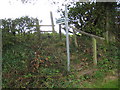
Footpath in Haddon Lane
The start of the footpath climbs some rough steps through the hedge
Image: © Peter Fleming
Taken: 16 Sep 2007
0.23 miles
3
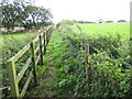
Footpath in Haddon Lane
After clearing the hedge the path follows a narrow fenced section.
Image: © Peter Fleming
Taken: 16 Sep 2007
0.24 miles