IMAGES TAKEN NEAR TO
Dale Close, NEWCASTLE, ST5 5DN
Introduction
This page details the photographs taken nearby to Dale Close, ST5 5DN by members of the Geograph project.
The Geograph project started in 2005 with the aim of publishing, organising and preserving representative images for every square kilometre of Great Britain, Ireland and the Isle of Man.

There are currently over 7.5m images from over14,400 individuals and you can help contribute to the project by visiting https://www.geograph.org.uk
Image Map
Images are licensed for reuse under creativecommons.org/licenses/by-sa/2.0
Notes
- Clicking on the map will re-center to the selected point.
- The higher the marker number, the further away the image location is from the centre of the postcode.
Image Listing (14 Images Found)
Images are licensed for reuse under creativecommons.org/licenses/by-sa/2.0
Image
Details
Distance
1
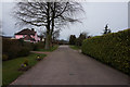
Sandy Fields
Off Newcastle Road, Baldwins Gate.
Image: © Ian S
Taken: 1 Apr 2016
0.08 miles
4
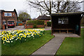
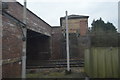
Baldwin's Gate Methodist Church
On Newcastle Road, Baldwins Gate.
Image: © Ian S
Taken: 1 Apr 2016
0.10 miles
5
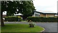
Baldwin's Gate Primary School
Off Tollgate Avenue.
Image: © Jonathan Billinger
Taken: 6 Sep 2016
0.11 miles
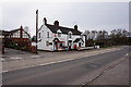
7
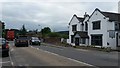
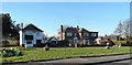
A53 at Baldwin's Gate
The Sheet Anchor awaits Tuesday afternoon custom.
The understated grey car, with a personalised plate, heading towards Loggerheads, is an Overfinch Range Rover: see http://www.overfinch.com/
Image: © Jonathan Billinger
Taken: 6 Sep 2016
0.21 miles
10
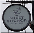
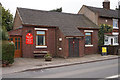
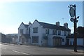
Sheet Anchor, Baldwins Gate
http://www.geograph.org.uk/photo/4904539
Image: © Ian S
Taken: 1 Apr 2016
0.22 miles