IMAGES TAKEN NEAR TO
Radstone Rise, NEWCASTLE, ST5 4JB
Introduction
This page details the photographs taken nearby to Radstone Rise, ST5 4JB by members of the Geograph project.
The Geograph project started in 2005 with the aim of publishing, organising and preserving representative images for every square kilometre of Great Britain, Ireland and the Isle of Man.

There are currently over 7.5m images from over14,400 individuals and you can help contribute to the project by visiting https://www.geograph.org.uk
Image Map (Loading...)


Getting Data...Please wait
Leaflet Map data © OpenStreetMap
Images are licensed for reuse under creativecommons.org/licenses/by-sa/2.0
Notes
- Clicking on the map will re-center to the selected point.
- The higher the marker number, the further away the image location is from the centre of the postcode.
Image Listing (34 Images Found)
Images are licensed for reuse under creativecommons.org/licenses/by-sa/2.0
Image
Details
Distance
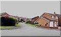
3
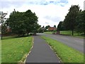
Kennet Close
looking in the other direction from picture Image
Image: © David Bagshaw
Taken: 3 Feb 2007
0.14 miles
4
Kennet Close Newcastle-under-Lyme
Looking down the road towards Rowley Wood.
Image: © David Bagshaw
Taken: 3 Feb 2007
0.14 miles
5
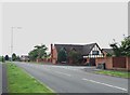
Westbury Park: Terrington Drive junction with Westbury Road
Image: © Jonathan Hutchins
Taken: 25 Jun 2016
0.15 miles
7
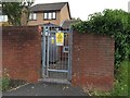
Westbury Park: electricity substation
Image: © Jonathan Hutchins
Taken: 25 Jun 2016
0.15 miles
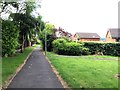
10
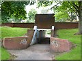
Westbury Park: underpass beneath Westbury Road
Image: © Jonathan Hutchins
Taken: 25 Jun 2016
0.17 miles