IMAGES TAKEN NEAR TO
Oakwood Lane, NEWCASTLE, ST5 4FD
Introduction
This page details the photographs taken nearby to Oakwood Lane, ST5 4FD by members of the Geograph project.
The Geograph project started in 2005 with the aim of publishing, organising and preserving representative images for every square kilometre of Great Britain, Ireland and the Isle of Man.

There are currently over 7.5m images from over14,400 individuals and you can help contribute to the project by visiting https://www.geograph.org.uk
Image Map
Images are licensed for reuse under creativecommons.org/licenses/by-sa/2.0
Notes
- Clicking on the map will re-center to the selected point.
- The higher the marker number, the further away the image location is from the centre of the postcode.
Image Listing (3 Images Found)
Images are licensed for reuse under creativecommons.org/licenses/by-sa/2.0
Image
Details
Distance
1

Wesleyan Church, Acton
Although due to close in the near future this little church is currently also supporting the congregation from St Thomas, Butterton which is being refurbished Image
Image: © Steve Lewin
Taken: 7 Jun 2007
0.13 miles
3
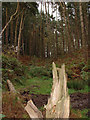
Fallen tree
Fallen tree in Swynnerton Old Park
Image: © charles c
Taken: 24 Oct 2007
0.23 miles