IMAGES TAKEN NEAR TO
Leaswood Place, NEWCASTLE, ST5 4BU
Introduction
This page details the photographs taken nearby to Leaswood Place, ST5 4BU by members of the Geograph project.
The Geograph project started in 2005 with the aim of publishing, organising and preserving representative images for every square kilometre of Great Britain, Ireland and the Isle of Man.

There are currently over 7.5m images from over14,400 individuals and you can help contribute to the project by visiting https://www.geograph.org.uk
Image Map (Loading...)


Getting Data...Please wait
Leaflet Map data © OpenStreetMap
Images are licensed for reuse under creativecommons.org/licenses/by-sa/2.0
Notes
- Clicking on the map will re-center to the selected point.
- The higher the marker number, the further away the image location is from the centre of the postcode.
Image Listing (14 Images Found)
Images are licensed for reuse under creativecommons.org/licenses/by-sa/2.0
Image
Details
Distance
2
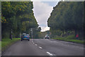
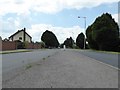
Newcastle-Under-Lyme : Clayton Road A519
Heading along Clayton Road in Clayton.
Image: © Lewis Clarke
Taken: 22 Sep 2019
0.20 miles
3

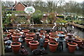
Northwood Garden Centre, Clayton Road
Off the A519 approaching Newcastle-under-Lyme. If travelling the M6, the coffee shop makes a pleasanter stop than M6 services.
Image: © Robin Stott
Taken: 28 Mar 2009
0.20 miles