IMAGES TAKEN NEAR TO
Salop Grove, NEWCASTLE, ST5 3EB
Introduction
This page details the photographs taken nearby to Salop Grove, ST5 3EB by members of the Geograph project.
The Geograph project started in 2005 with the aim of publishing, organising and preserving representative images for every square kilometre of Great Britain, Ireland and the Isle of Man.

There are currently over 7.5m images from over14,400 individuals and you can help contribute to the project by visiting https://www.geograph.org.uk
Image Map (Loading...)


Getting Data...Please wait
Leaflet Map data © OpenStreetMap
Images are licensed for reuse under creativecommons.org/licenses/by-sa/2.0
Notes
- Clicking on the map will re-center to the selected point.
- The higher the marker number, the further away the image location is from the centre of the postcode.
Image Listing (30 Images Found)
Images are licensed for reuse under creativecommons.org/licenses/by-sa/2.0
Image
Details
Distance
1
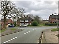
Newcastle-under-Lyme: junction of Warwick Avenue and Stafford Crescent
Image: © Jonathan Hutchins
Taken: 11 Mar 2017
0.07 miles
2
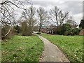
Newcastle-under-Lyme: path between Stafford Crescent and Wiltshire Grove
Image: © Jonathan Hutchins
Taken: 11 Mar 2017
0.08 miles
3
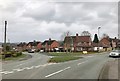
Newcastle-under-Lyme: junction of Warwick and Hereford Avenues
Image: © Jonathan Hutchins
Taken: 11 Mar 2017
0.10 miles
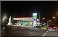
5

Newcastle-Under-Lyme : Texaco
A Texaco on Clayton Road.
Image: © Lewis Clarke
Taken: 22 Sep 2019
0.15 miles
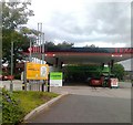
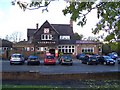
8

Newcastle-under-Lyme: the Gatehouse, Clayton
Image: © Jonathan Hutchins
Taken: 11 Mar 2017
0.16 miles
9
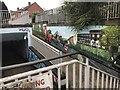
Newcastle-under-Lyme: subway art at the Clayton A519
Image: © Jonathan Hutchins
Taken: 11 Mar 2017
0.17 miles
10
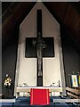
Altar and cross in St James the Great, Clayton
Image: © Jonathan Hutchins
Taken: 17 Nov 2022
0.17 miles