IMAGES TAKEN NEAR TO
Bunny Hill, NEWCASTLE, ST5 3BT
Introduction
This page details the photographs taken nearby to Bunny Hill, ST5 3BT by members of the Geograph project.
The Geograph project started in 2005 with the aim of publishing, organising and preserving representative images for every square kilometre of Great Britain, Ireland and the Isle of Man.

There are currently over 7.5m images from over14,400 individuals and you can help contribute to the project by visiting https://www.geograph.org.uk
Image Map (Loading...)


Getting Data...Please wait
Leaflet Map data © OpenStreetMap
Images are licensed for reuse under creativecommons.org/licenses/by-sa/2.0
Notes
- Clicking on the map will re-center to the selected point.
- The higher the marker number, the further away the image location is from the centre of the postcode.
Image Listing (47 Images Found)
Images are licensed for reuse under creativecommons.org/licenses/by-sa/2.0
Image
Details
Distance
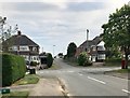
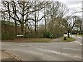
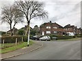
3
Newcastle-under-Lyme: junction of Buckmaster Avenue and Lilleshall Road
Image: © Jonathan Hutchins
Taken: 11 Mar 2017
0.05 miles
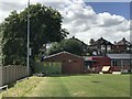
5
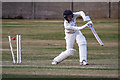
Newcastle and Hartshill Cricket Club
https://newcastleandhartshill.play-cricket.com/
Image: © Brian Deegan
Taken: 1 Jul 2018
0.08 miles
7
Newcastle-under-Lyme: Lilleshall Road at its junction with Stafford Avenue
Image: © Jonathan Hutchins
Taken: 11 Mar 2017
0.10 miles
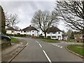
8
Newcastle-under-Lyme: junction of Buckmaster Avenue and Deakin Grove
Image: © Jonathan Hutchins
Taken: 11 Mar 2017
0.11 miles
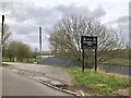
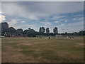
9
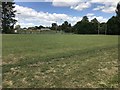
Rugby pitch
This is the home ground of Newcastle RUFC.
Image: © Jonathan Hutchins
Taken: 21 Jun 2018
0.11 miles