IMAGES TAKEN NEAR TO
Higherland, NEWCASTLE, ST5 2TL
Introduction
This page details the photographs taken nearby to Higherland, ST5 2TL by members of the Geograph project.
The Geograph project started in 2005 with the aim of publishing, organising and preserving representative images for every square kilometre of Great Britain, Ireland and the Isle of Man.

There are currently over 7.5m images from over14,400 individuals and you can help contribute to the project by visiting https://www.geograph.org.uk
Image Map
Images are licensed for reuse under creativecommons.org/licenses/by-sa/2.0
Notes
- Clicking on the map will re-center to the selected point.
- The higher the marker number, the further away the image location is from the centre of the postcode.
Image Listing (170 Images Found)
Images are licensed for reuse under creativecommons.org/licenses/by-sa/2.0
Image
Details
Distance
1
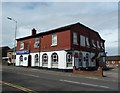
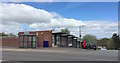
Newcastle-under-Lyme: Indian restaurant on Higherland
The Bilash restaurant and Asha Tandoori Takeaway was formerly a pub, the Lord Nelson Hotel, though the building has been heavily altered since then.
Image: © Jonathan Hutchins
Taken: 15 Apr 2015
0.02 miles
2
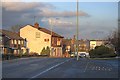
Higherland
The peculiar name of this road in Newcastle under Lyme.
Image: © Mick Garratt
Taken: 20 Feb 2010
0.03 miles
3
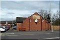
Newcastle-under-Lyme: Orme Amateur Boxing Club
Image: © Jonathan Hutchins
Taken: 15 Apr 2015
0.03 miles
4
Newcastle-under-Lyme: Pool Street Garage
Image: © Jonathan Hutchins
Taken: 11 Jul 2015
0.05 miles
5
Newcastle-under-Lyme: Drayton Street shops
The sign above the bus shelter indicates that the shops are owned and managed by Aspire Housing, a local housing association.
Image: © Jonathan Hutchins
Taken: 4 May 2015
0.05 miles
6
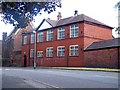
The Orme (Old Boys' School).
Photograph taken by student at CEDARS unit, Orme Building, Newcastle-under-Lyme Year 9 boy.
Image: © Kerry Widdowson
Taken: 16 Oct 2007
0.05 miles
7
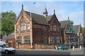
Newcastle-under-Lyme: Orme Boys' School
A Gothic structure of 1850, Grade II listed http://list.historicengland.org.uk/resultsingle.aspx?uid=1297487. More recently it was used as a County Council Community Centre
Image: © Jonathan Hutchins
Taken: 15 Apr 2015
0.06 miles
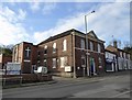
8
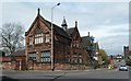
The Orme (Old Boys' School) Annex
Looking across Orme Road. This is almost directly opposite the position of where the other picture of the school was taken: Image
The ground floor of the annex was used for over 40 years by 'Peter Pan Nursery for children with special needs' until April 2011. ST5 2NB
Image: © Carl Farnell
Taken: 16 Jun 2011
0.06 miles
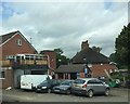
9
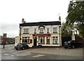
Newcastle-under-Lyme: Waggon and Horses on Higherland
Image: © Jonathan Hutchins
Taken: 24 Oct 2015
0.06 miles
10
Higherland Methodist Church
Website: http://www.higherlandchurch.org/
Image: © Jonathan Hutchins
Taken: 21 Feb 2018
0.06 miles