IMAGES TAKEN NEAR TO
Paris Avenue, NEWCASTLE, ST5 2RQ
Introduction
This page details the photographs taken nearby to Paris Avenue, ST5 2RQ by members of the Geograph project.
The Geograph project started in 2005 with the aim of publishing, organising and preserving representative images for every square kilometre of Great Britain, Ireland and the Isle of Man.

There are currently over 7.5m images from over14,400 individuals and you can help contribute to the project by visiting https://www.geograph.org.uk
Image Map (Loading...)


Getting Data...Please wait
Leaflet Map data © OpenStreetMap
Images are licensed for reuse under creativecommons.org/licenses/by-sa/2.0
Notes
- Clicking on the map will re-center to the selected point.
- The higher the marker number, the further away the image location is from the centre of the postcode.
Image Listing (7 Images Found)
Images are licensed for reuse under creativecommons.org/licenses/by-sa/2.0
Image
Details
Distance
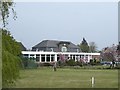
2
Newcastle Under Lyme Golf Course
Currently closed because of the Coronavirus (COVID-19) shut down. Walked from home. First time I have logged my home grid ref :)
Image: © Brian Deegan
Taken: 28 Mar 2020
0.17 miles
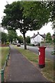
3
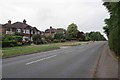
Sneyd Ave
A leafy suburb of Newcastle Under Lyme
Image: © Glyn Baker
Taken: 21 Jul 2013
0.18 miles
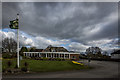
4
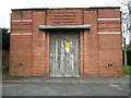
Electricity sub station, Howard Grove, Westlands
Image: © Alex McGregor
Taken: 18 Apr 2013
0.20 miles
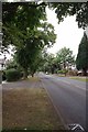
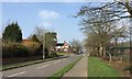
5
Dairy Cottage
The junction of Thistleberry Av and The Thistles
Image: © Glyn Baker
Taken: 21 Jul 2013
0.23 miles
6
Newcastle-under-Lyme: Emery Avenue
Image: © Jonathan Hutchins
Taken: 18 Mar 2015
0.24 miles