IMAGES TAKEN NEAR TO
Orme Road, NEWCASTLE, ST5 2NB
Introduction
This page details the photographs taken nearby to Orme Road, ST5 2NB by members of the Geograph project.
The Geograph project started in 2005 with the aim of publishing, organising and preserving representative images for every square kilometre of Great Britain, Ireland and the Isle of Man.

There are currently over 7.5m images from over14,400 individuals and you can help contribute to the project by visiting https://www.geograph.org.uk
Image Map (Loading...)


Getting Data...Please wait
Leaflet Map data © OpenStreetMap
Images are licensed for reuse under creativecommons.org/licenses/by-sa/2.0
Notes
- Clicking on the map will re-center to the selected point.
- The higher the marker number, the further away the image location is from the centre of the postcode.
Image Listing (163 Images Found)
Images are licensed for reuse under creativecommons.org/licenses/by-sa/2.0
Image
Details
Distance
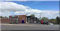
1
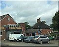
Newcastle-under-Lyme: Pool Street Garage
Image: © Jonathan Hutchins
Taken: 11 Jul 2015
0.03 miles
2
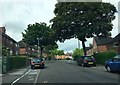
Newcastle-under-Lyme: Drayton Street
On the left, Cross May Street branches off from Drayton Street.
Image: © Jonathan Hutchins
Taken: 11 Jul 2015
0.05 miles
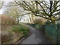
3
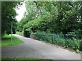
Newcastle-under-Lyme: path alongside Lyme Brook
Image: © Jonathan Hutchins
Taken: 11 Jul 2015
0.06 miles
4
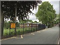
Newcastle-under-Lyme: St Giles' and St George's CofE Academy
Image: © Jonathan Hutchins
Taken: 11 Jul 2015
0.07 miles
6
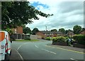
Newcastle-under-Lyme: Drayton Street shops
The sign above the bus shelter indicates that the shops are owned and managed by Aspire Housing, a local housing association.
Image: © Jonathan Hutchins
Taken: 4 May 2015
0.08 miles
7
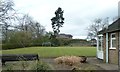
Newcastle-under-Lyme: Queen Elizabeth Park bowling green
The Corporation acquired this site in the 1930s, and in 1939 decided to convert it into a public park. War delayed the completion of this work, and it was formally opened in 1944. Facilities included this bowling green. On the far side of the green can be seen the remains of the motte of the castle which gave Newcastle its name - see http://www.geograph.org.uk/photo/4216996.
Image: © Jonathan Hutchins
Taken: 15 Apr 2015
0.08 miles
8
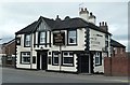
Newcastle-under-Lyme: The Sneyd Arms on Higherland
Image: © Jonathan Hutchins
Taken: 15 Apr 2015
0.09 miles
9
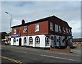
Newcastle-under-Lyme: Indian restaurant on Higherland
The Bilash restaurant and Asha Tandoori Takeaway was formerly a pub, the Lord Nelson Hotel, though the building has been heavily altered since then.
Image: © Jonathan Hutchins
Taken: 15 Apr 2015
0.09 miles