IMAGES TAKEN NEAR TO
Friarswood Road, NEWCASTLE, ST5 2EF
Introduction
This page details the photographs taken nearby to Friarswood Road, ST5 2EF by members of the Geograph project.
The Geograph project started in 2005 with the aim of publishing, organising and preserving representative images for every square kilometre of Great Britain, Ireland and the Isle of Man.

There are currently over 7.5m images from over14,400 individuals and you can help contribute to the project by visiting https://www.geograph.org.uk
Image Map
Images are licensed for reuse under creativecommons.org/licenses/by-sa/2.0
Notes
- Clicking on the map will re-center to the selected point.
- The higher the marker number, the further away the image location is from the centre of the postcode.
Image Listing (189 Images Found)
Images are licensed for reuse under creativecommons.org/licenses/by-sa/2.0
Image
Details
Distance
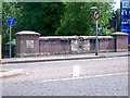
1

Cycleway Beside Lyme Brook
The Lyme Brook is to the left
Image: © Glyn Baker
Taken: 19 Jul 2013
0.03 miles
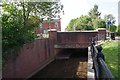
2
Road bridge over Lyme Brook, Newcastle under Lyme
This is the south eastern side of the bridge on Brook Lane, (B5043)
The parapet sculpture is dated 1995, by Ian Randall. It was commissioned to commemorate the completion of flood prevention works in 2000.
Image: © Carl Farnell
Taken: 16 Jun 2011
0.05 miles
3
The Lyme Brook Newcastle
This is the stream that gives this town its name.
Image: © Glyn Baker
Taken: 19 Jul 2013
0.05 miles
4

Newcastle-under-Lyme: Friarswood Veterinary Centre
Image: © Jonathan Hutchins
Taken: 4 May 2015
0.05 miles
5

Newcastle-under-Lyme cemetery
One of the older and less well tended parts of the cemetery.
Image: © Jonathan Hutchins
Taken: 17 Jun 2015
0.06 miles
6
Newcastle-Under-Lyme : Morrisons Entrance
Entry to Morrisons off Brook Lane.
Image: © Lewis Clarke
Taken: 22 Sep 2019
0.06 miles
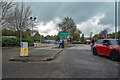
7
Newcastle-Under-Lyme : Brook Lane B5043
Friarswood Road off Brook Lane.
Image: © Lewis Clarke
Taken: 22 Sep 2019
0.06 miles
8
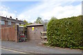
Newcastle-under-Lyme: electricity substation on Lymewood Grove
Western Power substation ID no.113770. The Iceland supermarket trolley adds a piquant touch.
Image: © Jonathan Hutchins
Taken: 4 May 2015
0.06 miles
9
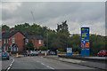
Newcastle-Under-Lyme : Clayton Road A519
Looking along Clayton Road.
Image: © Lewis Clarke
Taken: 22 Sep 2019
0.07 miles
10
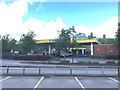
Newcastle-under-Lyme: Morrisons petrol station
The building behind is No.1 London Road http://www.geograph.org.uk/photo/4317394
Image: © Jonathan Hutchins
Taken: 19 May 2015
0.07 miles