IMAGES TAKEN NEAR TO
Mellard Street, NEWCASTLE, ST5 2DN
Introduction
This page details the photographs taken nearby to Mellard Street, ST5 2DN by members of the Geograph project.
The Geograph project started in 2005 with the aim of publishing, organising and preserving representative images for every square kilometre of Great Britain, Ireland and the Isle of Man.

There are currently over 7.5m images from over14,400 individuals and you can help contribute to the project by visiting https://www.geograph.org.uk
Image Map (Loading...)


Getting Data...Please wait
Leaflet Map data © OpenStreetMap
Images are licensed for reuse under creativecommons.org/licenses/by-sa/2.0
Notes
- Clicking on the map will re-center to the selected point.
- The higher the marker number, the further away the image location is from the centre of the postcode.
Image Listing (106 Images Found)
Images are licensed for reuse under creativecommons.org/licenses/by-sa/2.0
Image
Details
Distance
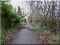
1
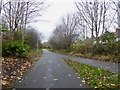
Newcastle-under-Lyme: path junction on cycleway
The path on the right slopes upwards to meet the A34 at ground level. The main path is a National Cycle Route, and is also the route of the long-gone Newcastle-Market Drayton railway line.
Image: © Jonathan Hutchins
Taken: 20 Nov 2016
0.04 miles
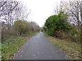
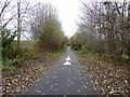
2
Newcastle-under-Lyme: path junction on cycleway
The path on the left slopes upwards to meet the A34 at ground level. The main path is a National Cycle Route, and is also the route of the long-gone Newcastle-Market Drayton railway line.
Image: © Jonathan Hutchins
Taken: 20 Nov 2016
0.04 miles
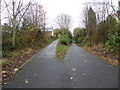
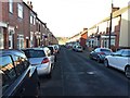
3

Newcastle-Under-Lyme : Ashfields New Road
Looking along Ashfields New Road.
Image: © Lewis Clarke
Taken: 22 Sep 2019
0.06 miles
4
Newcastle-under-Lyme: path and cycleway
Image: © Jonathan Hutchins
Taken: 20 Nov 2016
0.06 miles
5
Newcastle-under-Lyme: footpath emerges onto Ashfields New Road
Image: © Jonathan Hutchins
Taken: 20 Nov 2016
0.06 miles
6
Newcastle-under-Lyme: path with staggered barriers
Image: © Jonathan Hutchins
Taken: 20 Nov 2016
0.06 miles
7
Newcastle-under-Lyme: Ashfields New Road
Image: © Jonathan Hutchins
Taken: 4 Dec 2016
0.06 miles
8
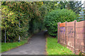
Newcastle-Under-Lyme : Footpath
A footpath heading from Ashfields New Road to the former Stoke-Market Drayton Line.
Image: © Lewis Clarke
Taken: 22 Sep 2019
0.06 miles
9
Newcastle-under-Lyme: path and cycleway
Image: © Jonathan Hutchins
Taken: 20 Nov 2016
0.06 miles
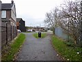
10
Newcastle-under-Lyme: Roberts Avenue
Image: © Jonathan Hutchins
Taken: 4 Dec 2016
0.07 miles