IMAGES TAKEN NEAR TO
West Brampton, NEWCASTLE, ST5 2BB
Introduction
This page details the photographs taken nearby to West Brampton, ST5 2BB by members of the Geograph project.
The Geograph project started in 2005 with the aim of publishing, organising and preserving representative images for every square kilometre of Great Britain, Ireland and the Isle of Man.

There are currently over 7.5m images from over14,400 individuals and you can help contribute to the project by visiting https://www.geograph.org.uk
Image Map
Images are licensed for reuse under creativecommons.org/licenses/by-sa/2.0
Notes
- Clicking on the map will re-center to the selected point.
- The higher the marker number, the further away the image location is from the centre of the postcode.
Image Listing (418 Images Found)
Images are licensed for reuse under creativecommons.org/licenses/by-sa/2.0
Image
Details
Distance
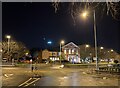
1
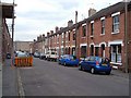
West Brompton, Newcastle-Under-Lyme
A street of terraced houses just north of the town centre and the ring road.
Image: © Derek Harper
Taken: 30 Jun 2006
0.04 miles
2
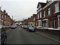
Newcastle-under-Lyme: Florence Street
Image: © Jonathan Hutchins
Taken: 23 Nov 2015
0.04 miles
3
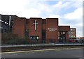
Newcastle-under-Lyme: Methodist Church on Ryecroft
This new church opened on 9th May 1981, as a replacement for the Ebenezer Church http://www.geograph.org.uk/photo/4339696.
Image: © Jonathan Hutchins
Taken: 7 Feb 2015
0.06 miles
4
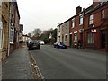
Newcastle-under-Lyme: West Brampton
Image: © Jonathan Hutchins
Taken: 23 Nov 2015
0.06 miles
5
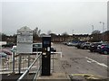
Newcastle-under-Lyme: Ryecroft car park
This ground-level municipal car park was constructed out of the split-level car park of the former Sainsbury's, seen here in its partly demolished state http://www.geograph.org.uk/photo/3935572
Image: © Jonathan Hutchins
Taken: 23 Nov 2015
0.06 miles
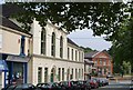
6
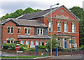
Newcastle-under-Lyme - Ebenezer House
The blue plaque attached to this building in 2006 by the Newcastle-under-Lyme Civic Society says:
"Ebenezer House.
Built as Ebenezer Chapel in 1857.
Became Ebenezer Church in 1897.
Closed 1981.
First occupied by Thompson Wright in 2000."
See http://newcastleunderlymecivicsociety.org.uk/tag/ebenezer/ for more details.
Image: © Dave Bevis
Taken: 24 Jun 2013
0.07 miles
7
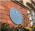
Newcastle-under-Lyme: Ebenezer House, Ryecroft (detail)
For the building itself see http://www.geograph.org.uk/photo/4339696.
Image: © Jonathan Hutchins
Taken: 7 Feb 2015
0.07 miles
8
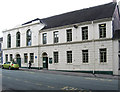
Newcastle-under-Lyme - Ebenezer Sunday School
Image: © Dave Bevis
Taken: 24 Jun 2013
0.07 miles
9
Ebenezer House from Merrial Street
Ebenezer House is Grade II listed, see https://historicengland.org.uk/listing/the-list/list-entry/1219957
Image: © Jonathan Hutchins
Taken: 21 Dec 2022
0.07 miles
10
Merrial Street, Newcastle-Under-Lyme
This section of Merrial Street was formerly called Marsh Street. Across Ryecroft (the A52 ring road) is Ebenezer House, a former Methodist Church, dating from the 1850s http://www.britishlistedbuildings.co.uk/en-385968-ebenezer-house-newcastle-under-lyme . It is now occupied by businesses.
Image: © Derek Harper
Taken: 30 Jun 2006
0.07 miles