IMAGES TAKEN NEAR TO
Merrial Street, NEWCASTLE, ST5 2AD
Introduction
This page details the photographs taken nearby to Merrial Street, ST5 2AD by members of the Geograph project.
The Geograph project started in 2005 with the aim of publishing, organising and preserving representative images for every square kilometre of Great Britain, Ireland and the Isle of Man.

There are currently over 7.5m images from over14,400 individuals and you can help contribute to the project by visiting https://www.geograph.org.uk
Image Map (Loading...)


Getting Data...Please wait
Leaflet Map data © OpenStreetMap
Images are licensed for reuse under creativecommons.org/licenses/by-sa/2.0
Notes
- Clicking on the map will re-center to the selected point.
- The higher the marker number, the further away the image location is from the centre of the postcode.
Image Listing (477 Images Found)
Images are licensed for reuse under creativecommons.org/licenses/by-sa/2.0
Image
Details
Distance
1
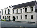
Newcastle-under-Lyme - Ebenezer Sunday School
Image: © Dave Bevis
Taken: 24 Jun 2013
0.01 miles
2
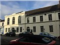
Newcastle-under-Lyme: Ebenezer School Rooms, Merrial Street
For the blue plaque see http://www.geograph.org.uk/photo/4339879.
Image: © Jonathan Hutchins
Taken: 7 Feb 2015
0.01 miles
3
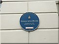
Newcastle-under-Lyme: Ebenezer School Rooms, Merrial Street (detail)
For the building itself see http://www.geograph.org.uk/photo/4339861.
Image: © Jonathan Hutchins
Taken: 7 Feb 2015
0.01 miles
4
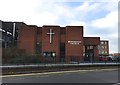
Newcastle-under-Lyme: Methodist Church on Ryecroft
This new church opened on 9th May 1981, as a replacement for the Ebenezer Church http://www.geograph.org.uk/photo/4339696.
Image: © Jonathan Hutchins
Taken: 7 Feb 2015
0.01 miles
5
Merrial Street, Newcastle-Under-Lyme
This section of Merrial Street was formerly called Marsh Street. Across Ryecroft (the A52 ring road) is Ebenezer House, a former Methodist Church, dating from the 1850s http://www.britishlistedbuildings.co.uk/en-385968-ebenezer-house-newcastle-under-lyme . It is now occupied by businesses.
Image: © Derek Harper
Taken: 30 Jun 2006
0.01 miles
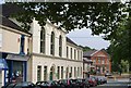
6
Newcastle-under-Lyme: 4-10 Merrial Street
From left to right:
10 - Elixir (beauty and skincare)
8 - Lumiere (unisex hairdressers)
6 - Elite (wool shop, haberdashery, alterations)
4 - Age UK (charity shop and office)
Image: © Jonathan Hutchins
Taken: 4 Feb 2017
0.01 miles
7
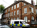
The Police Station
Wandering down Merrial Street I wondered why there were so many police vehicles parked up, then I realised that this imposing building is the headquarters for the Newcastle-Under-Lyme Borough Police.
Image: © Jonathan Kington
Taken: 21 Jun 2011
0.02 miles
8
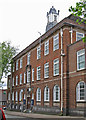
Newcastle-under-Lyme - Police Station
On Merrial Street. For an alternative view, please see Image
Image: © Dave Bevis
Taken: 24 Jun 2013
0.02 miles
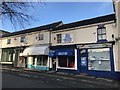
9
Newcastle-under-Lyme: Fogg Street East
On the right is RAWR, a 'juice and superfood bar'.
Image: © Jonathan Hutchins
Taken: 12 Mar 2017
0.03 miles
10
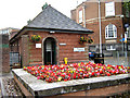
Colourful loo
The front of the Gents public toilets are extremely well decorated with floral displays, the Ladies and Disabled conveniences are round the corner to the right.
Image: © Jonathan Kington
Taken: 21 Jun 2011
0.04 miles