IMAGES TAKEN NEAR TO
Roebuck Centre, High Street, NEWCASTLE, ST5 1SW
Introduction
This page details the photographs taken nearby to Roebuck Centre, High Street, ST5 1SW by members of the Geograph project.
The Geograph project started in 2005 with the aim of publishing, organising and preserving representative images for every square kilometre of Great Britain, Ireland and the Isle of Man.

There are currently over 7.5m images from over14,400 individuals and you can help contribute to the project by visiting https://www.geograph.org.uk
Image Map
Images are licensed for reuse under creativecommons.org/licenses/by-sa/2.0
Notes
- Clicking on the map will re-center to the selected point.
- The higher the marker number, the further away the image location is from the centre of the postcode.
Image Listing (458 Images Found)
Images are licensed for reuse under creativecommons.org/licenses/by-sa/2.0
Image
Details
Distance
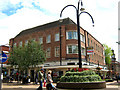
1
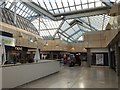
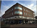
Newcastle-under-Lyme: Roebuck Centre
The Centre is on the site of a public house called The Angel, and a later building which was known as The Old Roebuck Coaching Inn, hence the name.
Image: © Jonathan Hutchins
Taken: 4 Feb 2017
0.00 miles
2
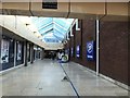
Newcastle-under-Lyme: Roebuck Centre
The Centre is on the site of a public house called The Angel, and a later building which was known as The Old Roebuck Coaching Inn, hence the name.
This view is from the entrance to/exit from the Midway multi-storey car park.
Image: © Jonathan Hutchins
Taken: 4 Feb 2017
0.01 miles
3
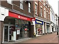
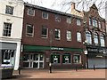
Newcastle-under-Lyme: High Street shops
Santander is at no.58, Card Factory at no.56.
Image: © Jonathan Hutchins
Taken: 12 Feb 2017
0.02 miles
4
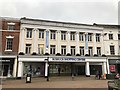
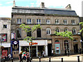
Newcastle-under-Lyme: Roebuck Shopping Centre
The Roebuck Centre was formerly Sutherland House, and the front elevation has been restored. The Centre is on the site of a public house called The Angel, and a later building which was known as The Old Roebuck Coaching Inn.
Image: © Jonathan Hutchins
Taken: 12 Feb 2017
0.02 miles
5
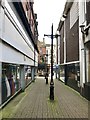
Newcastle-under-Lyme: 46-48 High Street
Image: © Jonathan Hutchins
Taken: 12 Mar 2017
0.03 miles
6
Lancaster Building from the north-west
Image: © Jonathan Kington
Taken: 21 Jun 2011
0.04 miles
7
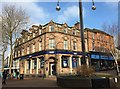
Clinton Cards and HSBC
This was once the site of the house where Thomas Harrison was born. Harrison became a Major-General and was second in command to Oliver Cromwell of the Parliamentarian forces during the Civil War. He was later tried for regicide and hung, drawn and quartered at Charing Cross in October 1660. There seems to be some discrepancy as to the date of his birth- a brass plate affixed to the wall of the bank states 1616, while published biographies claim he was born in 1606.
Image: © Jonathan Kington
Taken: 21 Jun 2011
0.04 miles
9
Newcastle-under-Lyme: Lancaster Building
The corner of the High Street and Ironmarket. An Art Deco block of shops and offices 1936-40, well described in http://www.midlandsheritage.co.uk/miscellaneous-heritage/3402-art-deco-lancaster-building-newcastle-under-lyme.html. See also http://www.geograph.org.uk/photo/4339566.
Image: © Jonathan Hutchins
Taken: 7 Feb 2015
0.04 miles
10
Newcastle-under-Lyme: 41 High Street
On the corner of High Street and Ironmarket.
Image: © Jonathan Hutchins
Taken: 7 Feb 2015
0.04 miles