IMAGES TAKEN NEAR TO
High Street, NEWCASTLE, ST5 1RA
Introduction
This page details the photographs taken nearby to High Street, ST5 1RA by members of the Geograph project.
The Geograph project started in 2005 with the aim of publishing, organising and preserving representative images for every square kilometre of Great Britain, Ireland and the Isle of Man.

There are currently over 7.5m images from over14,400 individuals and you can help contribute to the project by visiting https://www.geograph.org.uk
Image Map (Loading...)


Getting Data...Please wait
Leaflet Map data © OpenStreetMap
Images are licensed for reuse under creativecommons.org/licenses/by-sa/2.0
Notes
- Clicking on the map will re-center to the selected point.
- The higher the marker number, the further away the image location is from the centre of the postcode.
Image Listing (435 Images Found)
Images are licensed for reuse under creativecommons.org/licenses/by-sa/2.0
Image
Details
Distance
1

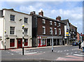
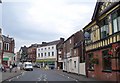
Newcastle-under-Lyme: 14 and 16 High Street
Plant and Wilton are a firm of butchers. The building is originally early 17th century with early 19th century modifications, and is Grade II listed.
Historic England entry; https://www.historicengland.org.uk/listing/the-list/list-entry/1219576
Image: © Jonathan Hutchins
Taken: 4 Feb 2017
0.00 miles
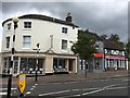
2
Newcastle-under-Lyme - High Street from Merrial Street junction
Image: © Dave Bevis
Taken: 24 Jun 2013
0.01 miles
3
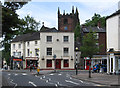
Newcastle-under-Lyme - High Street at end of Merrial Street
The tower of St Giles Church is in the background.
Image: © Dave Bevis
Taken: 24 Jun 2013
0.01 miles
4
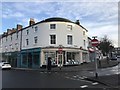
Newcastle-under-Lyme: shop on corner of Merrial Street
An image from April 2015 http://www.geograph.org.uk/photo/4433447 shows the shop under refurbishment. It has become an estate agents, Stephenson Browne.
Image: © Jonathan Hutchins
Taken: 4 Feb 2017
0.01 miles
5
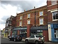
Newcastle-under-Lyme: 5-9 High Street
Image: © Jonathan Hutchins
Taken: 11 Jul 2015
0.01 miles
6
Liverpool Road, Newcastle-Under-Lyme
A reverse view of Image, with the Full Moon on the right. At the junction with Bridge Street, High Street continues ahead.
Image: © Derek Harper
Taken: 30 Jun 2006
0.02 miles
7
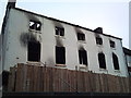
Newcastle-under-Lyme: after the Poundstretcher fire
Fire broke out around 7 a.m. on 28th February 2011 in the Poundstretcher store, High Street, Newcastle-under-Lyme. The store was gutted. It is pictured here a month later.
Update: nearly six years later, reconstruction is nearly complete, see http://www.geograph.org.uk/photo/5274432
Image: © Jonathan Hutchins
Taken: 27 Mar 2011
0.02 miles
8
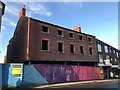
Newcastle-under-Lyme: rebuilding after fire on High Street
Almost exactly six years before this photo, the building on this site, which housed a Poundstretcher store, was devastated by fire - see http://www.geograph.org.uk/photo/4279609
Image: © Jonathan Hutchins
Taken: 4 Feb 2017
0.02 miles
9
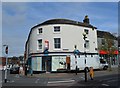
Newcastle-under-Lyme: shop on corner of Merrial Street
Undergoing refurbishment having changed hands. What is 'coming soon', I wonder?
The answer - an estate agents - can be seen in this photo from Feb 2017 http://www.geograph.org.uk/photo/5272294
Image: © Jonathan Hutchins
Taken: 15 Apr 2015
0.02 miles
10
Newcastle-under-Lyme: Merrial Street
Three adjacent estate agents.
Image: © Jonathan Hutchins
Taken: 11 Jul 2015
0.02 miles