IMAGES TAKEN NEAR TO
London Road, NEWCASTLE, ST5 1NZ
Introduction
This page details the photographs taken nearby to London Road, ST5 1NZ by members of the Geograph project.
The Geograph project started in 2005 with the aim of publishing, organising and preserving representative images for every square kilometre of Great Britain, Ireland and the Isle of Man.

There are currently over 7.5m images from over14,400 individuals and you can help contribute to the project by visiting https://www.geograph.org.uk
Image Map (Loading...)


Getting Data...Please wait
Leaflet Map data © OpenStreetMap
Images are licensed for reuse under creativecommons.org/licenses/by-sa/2.0
Notes
- Clicking on the map will re-center to the selected point.
- The higher the marker number, the further away the image location is from the centre of the postcode.
Image Listing (153 Images Found)
Images are licensed for reuse under creativecommons.org/licenses/by-sa/2.0
Image
Details
Distance
1
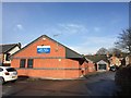
Newcastle-under-Lyme: Cherry Tree
Image: © Jonathan Hutchins
Taken: 11 Dec 2015
0.01 miles
2
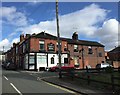
Newcastle-under-Lyme: The Cherry Tree
Large pub with large beer garden on London Road.
Image: © Jonathan Hutchins
Taken: 20 Mar 2015
0.01 miles
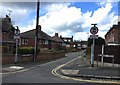
3
Newcastle-under-Lyme: junction of Stubbs Gate and London Road
Image: © Jonathan Hutchins
Taken: 27 Feb 2015
0.03 miles
4
Newcastle-under-Lyme: Castle Mona on Victoria Street
On the corner with Leech Street. The Castle Mona has a strong tradition of real ale and entertainment. It hosts an annual beer festival http://castlemona.co.uk.
Image: © Jonathan Hutchins
Taken: 27 Feb 2015
0.04 miles
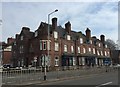
5
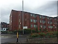
Newcastle-under-Lyme: Lyme Court on London Road
Lyme Court is a development of 56 sheltered flats for the over-60s, managed by Sanctuary Housing.
In the background on the left can be seen the Castle Mona pub http://www.geograph.org.uk/photo/4364138.
Image: © Jonathan Hutchins
Taken: 26 Jun 2015
0.04 miles
6
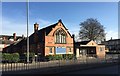
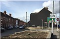
Newcastle-under-Lyme: former Newcastle Baptist Church
Newcastle Baptist Church is now based on Stafford Avenue, a mile to the south in the suburb of Clayton. According to the website http://www.newcastlebaptist.org.uk the church depicted here became too small for a growing church community.
The church and hall were demolished and the site cleared in early June 2017: see http://www.geograph.org.uk/photo/5436974
Image: © Jonathan Hutchins
Taken: 20 Jan 2015
0.04 miles
7
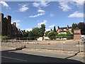
Site of Newcastle Baptist Church
The church and adjacent hall can be seen in http://www.geograph.org.uk/photo/4317338
After a couple of years lying vacant the buildings were demolished and the site razed in early June 2017.
Image: © Jonathan Hutchins
Taken: 15 Jun 2017
0.04 miles
8
Newcastle-under-Lyme: junction of Vessey Terrace and Belgrave Road
Image: © Jonathan Hutchins
Taken: 3 Mar 2015
0.07 miles
9
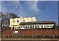
Newcastle-under-Lyme: Grosvenor Terrace
Numbered as 33-41 London Road, this building bears a date of 1883 on the side facing Grosvenor Road, and is on the local Council's Register of Locally Important Buildings and Structures. It is used as accommodation for clients of The Lyme Trust http://www.thelymetrust.co.uk/ , a charity set up in 1974 to provide supported accommodation for people living with mental health problems, and any associated substance misuse and addiction difficulties. No.37 is also the administrative headquarters of the charity.
Image: © Jonathan Hutchins
Taken: 20 Mar 2015
0.07 miles