IMAGES TAKEN NEAR TO
Hatrell Street, NEWCASTLE, ST5 1LX
Introduction
This page details the photographs taken nearby to Hatrell Street, ST5 1LX by members of the Geograph project.
The Geograph project started in 2005 with the aim of publishing, organising and preserving representative images for every square kilometre of Great Britain, Ireland and the Isle of Man.

There are currently over 7.5m images from over14,400 individuals and you can help contribute to the project by visiting https://www.geograph.org.uk
Image Map
Images are licensed for reuse under creativecommons.org/licenses/by-sa/2.0
Notes
- Clicking on the map will re-center to the selected point.
- The higher the marker number, the further away the image location is from the centre of the postcode.
Image Listing (174 Images Found)
Images are licensed for reuse under creativecommons.org/licenses/by-sa/2.0
Image
Details
Distance
1
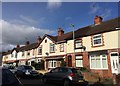
Newcastle-under-Lyme: Hatrell Street
The gable-end in the centre of the photo features a terracotta bas-relief of a bust of Edward VII with the date 1909 beneath. The King had visited Newcastle in 1906.
Image: © Jonathan Hutchins
Taken: 27 Feb 2015
0.03 miles

3
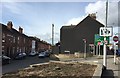
Newcastle-under-Lyme: junction of Stubbs Gate and London Road
Image: © Jonathan Hutchins
Taken: 27 Feb 2015
0.06 miles
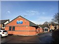
5
Newcastle-under-Lyme: St Bernard's Convent of Mercy off Refinery Street
The convent was founded in 1892 and moved to its present premises a year later. See http://www.ourladyofmercy.org.uk/ourstory/dsp-default.cfm?loadref=174
Image: © Jonathan Hutchins
Taken: 11 Jun 2015
0.06 miles
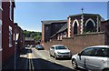
6
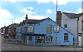
Newcastle-under-Lyme: Boat and Horses
The pub's name proclaims an association with the long-vanished Newcastle-under-Lyme canal: see the description accompanying Steven Birks' 2003 image http://www.geograph.org.uk/photo/344886 - in which, incidentally, the pub is a brick-red/terracotta hue rather than blue!
Image: © Jonathan Hutchins
Taken: 29 Jun 2015
0.06 miles
7
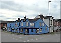
Newcastle-under-Lyme: Boat and Horses
The pub's name proclaims an association with the long-vanished Newcastle-under-Lyme canal: see the description accompanying Steven Birks' 2003 image http://www.geograph.org.uk/photo/344886 - in which, incidentally, the pub is a brick-red/terracotta hue rather than blue!
Image: © Jonathan Hutchins
Taken: 24 Sep 2016
0.06 miles
8
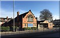
Newcastle-under-Lyme: former Newcastle Baptist Church
Newcastle Baptist Church is now based on Stafford Avenue, a mile to the south in the suburb of Clayton. According to the website http://www.newcastlebaptist.org.uk the church depicted here became too small for a growing church community.
The church and hall were demolished and the site cleared in early June 2017: see http://www.geograph.org.uk/photo/5436974
Image: © Jonathan Hutchins
Taken: 20 Jan 2015
0.07 miles
9
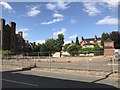
Site of Newcastle Baptist Church
The church and adjacent hall can be seen in http://www.geograph.org.uk/photo/4317338
After a couple of years lying vacant the buildings were demolished and the site razed in early June 2017.
Image: © Jonathan Hutchins
Taken: 15 Jun 2017
0.07 miles
10
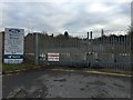
Newcastle-under-Lyme: former car dealership (1)
Bristol Street Motors, according to the website https://www.bristolstreet.co.uk , is the largest single Hyundai dealer in the UK and the third largest single UK Ford dealer. This branch in Newcastle closed some time around 2006. It occupied a large site on two levels, with a 70m forecourt on London Road, and a much bigger ramp-accessed area for workshops etc. behind and below alongside Lyme Valley Park. This is the entrance to the latter at the end of Lyme Valley Road, a cul-de-sac.
Image: © Jonathan Hutchins
Taken: 19 Jan 2015
0.07 miles