IMAGES TAKEN NEAR TO
Scott Street, NEWCASTLE, ST5 1AE
Introduction
This page details the photographs taken nearby to Scott Street, ST5 1AE by members of the Geograph project.
The Geograph project started in 2005 with the aim of publishing, organising and preserving representative images for every square kilometre of Great Britain, Ireland and the Isle of Man.

There are currently over 7.5m images from over14,400 individuals and you can help contribute to the project by visiting https://www.geograph.org.uk
Image Map (Loading...)


Getting Data...Please wait
Leaflet Map data © OpenStreetMap
Images are licensed for reuse under creativecommons.org/licenses/by-sa/2.0
Notes
- Clicking on the map will re-center to the selected point.
- The higher the marker number, the further away the image location is from the centre of the postcode.
Image Listing (376 Images Found)
Images are licensed for reuse under creativecommons.org/licenses/by-sa/2.0
Image
Details
Distance
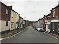
1
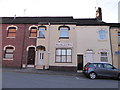
Looking west-southwest in Hassell Street
Image: © Basher Eyre
Taken: 3 May 2016
0.02 miles
2
Plenty of parking spaces in Hanover Street
Image: © Basher Eyre
Taken: 3 May 2016
0.04 miles
3
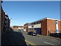
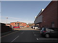
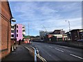
Barracks Road, Newcastle under Lyme
A section of the A527, which forms part of Newcastle's inner ring road. The bus is one of many that use Barracks Road, as the bus station is a short distance behind the photographer.
Image: © Richard Vince
Taken: 29 Jun 2013
0.05 miles
4
Newcastle-under-Lyme: School Street
On the left is the recently cleared Jubilee Baths site seen in http://www.geograph.org.uk/photo/4981069
Image: © Jonathan Hutchins
Taken: 2 Jun 2016
0.06 miles
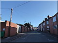
5
Looking from Hanover Street into School Street
Image: © Basher Eyre
Taken: 3 May 2016
0.06 miles
6
Newcastle-under-Lyme: Garden Street at junction with West Street
Image: © Jonathan Hutchins
Taken: 10 Mar 2015
0.06 miles
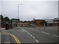
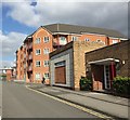
7
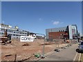
Newcastle-under-Lyme: new developments off Barrack Road
On the left, the new 'public sector hub' (see http://www.geograph.org.uk/photo/5273125 ); on the right the Sky Building, new student accommodation (see http://www.geograph.org.uk/photo/5273102 )
Image: © Jonathan Hutchins
Taken: 4 Feb 2017
0.06 miles
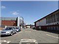
10
Newcastle-under-Lyme: redevelopment of former Jubilee Baths site
In 1906 the King Edward VII Memorial Baths was opened in Brunswick Street at a cost of £15,574. The building comprised of two Swimming Pools 100ft x 35 ft; 50ft x 20ft, Turkish Baths, 12 Wash Baths. In 1935 Newcastle Baths were described as the finest in the district, with the water ‘aerated, cleansed and purified’ by an up-to-date filtration plant. However, during the winter season the main pool was emptied and used as tennis and badminton courts.
Alterations were made in 1921, 1938-9 and 1946, The building originally had two Cornish Steam Boilers that were replaced by Lancashire boilers in the 1960’s. The building was refurbished during the 1970’s and opened as Jubilee Baths in 1977. In December 2010 a new Swimming Pool and leisure centre 'Jubilee 2' was opened on the land next to the original swimming pool. The Jubilee Baths has remained empty ever since. In 2010 Newcastle Council preposed to demolish the site to make way for 6 new retail units and an apartment block. Plans were left unfulfilled until 2016 when the site was finally cleared.
Some excellent photos of the derelict site may be viewed on the urban explorers' website 28DaysLater at:
http://www.28dayslater.co.uk/jubilee-swimming-pool-newcastle-under-lyme-july-2015.t97996
Image: © Jonathan Hutchins
Taken: 2 Jun 2016
0.07 miles