IMAGES TAKEN NEAR TO
Catherine Street, NEWCASTLE, ST5 0JH
Introduction
This page details the photographs taken nearby to Catherine Street, ST5 0JH by members of the Geograph project.
The Geograph project started in 2005 with the aim of publishing, organising and preserving representative images for every square kilometre of Great Britain, Ireland and the Isle of Man.

There are currently over 7.5m images from over14,400 individuals and you can help contribute to the project by visiting https://www.geograph.org.uk
Image Map (Loading...)


Getting Data...Please wait
Leaflet Map data © OpenStreetMap
Images are licensed for reuse under creativecommons.org/licenses/by-sa/2.0
Notes
- Clicking on the map will re-center to the selected point.
- The higher the marker number, the further away the image location is from the centre of the postcode.
Image Listing (55 Images Found)
Images are licensed for reuse under creativecommons.org/licenses/by-sa/2.0
Image
Details
Distance
1

Un-sheltered seating at Wolstanton Bowls Club
With just one panel remaining out of four there would be barely any protection from the elements.
Image: © Jonathan Hutchins
Taken: 21 Jan 2023
0.07 miles

3
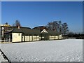
Bowls club and bowling green, Wolstanton Park
Image: © Jonathan Hutchins
Taken: 21 Jan 2023
0.09 miles
4
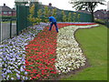
Patriotic flower-bed, Wolstanton Marsh
Beside the junction of Moreton Parade with Church Lane.
Image: © Derek Harper
Taken: 30 Jun 2006
0.10 miles
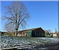
6
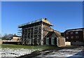
Moreton House with scaffolding
'Dated 1743. Brick, five bays and two and a half storeys. The first-floor windows segment-headed. Top parapet'. (Pevsner, The Buildings of England: Staffordshire (Penguin, 1974))
Image: © Jonathan Hutchins
Taken: 21 Jan 2023
0.12 miles
7
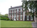
Moreton House, Wolstanton
It seems odd that this building, dating from 1743, is not listed. It overlooks Wolstanton Marsh. A blue plaque, commemorating the residence here of Sir Oliver Joseph Lodge FRS, discoverer of wireless telegraphy and inventor of the spark plug, during the 1870s, must have been placed on the building after this photo was taken http://www.thepotteries.org/tour/027.htm .
Image: © Derek Harper
Taken: 30 Jun 2006
0.12 miles
8
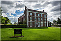
Moreton House, Wolstanton
Sir Oliver Joseph Lodge FRS discoverer of wireless telegraphy and inventor of the spark plug lived here during the 1870s (Blue Plaque). When Oliver Lodge was 12, the family moved from The Views in Penkhull to a larger residence, Moreton House, Wolstanton, where, in an outbuilding, he was able to undertake his first experiments.
The building was built in 1743 in the Georgian style, by Ralph Moreton and is currently flats.
No.12 Neville Malkin's "Grand Tour" of the Potteries
http://www.thepotteries.org/tour/027.htm
Sir Oliver Lodge Wiki >>> https://en.wikipedia.org/wiki/Oliver_Lodge
Image: © Brian Deegan
Taken: 5 Jul 2020
0.12 miles
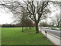
9
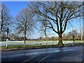
Wolstanton Marsh
Wolstanton Marsh is a large green space between May Bank and Wolstanton, given to the local people a long time ago by the Duchy of Lancaster as a recreational area in perpetuity.
Image: © Jonathan Hutchins
Taken: 21 Jan 2023
0.13 miles