IMAGES TAKEN NEAR TO
Grosvenor Place, NEWCASTLE, ST5 0HS
Introduction
This page details the photographs taken nearby to Grosvenor Place, ST5 0HS by members of the Geograph project.
The Geograph project started in 2005 with the aim of publishing, organising and preserving representative images for every square kilometre of Great Britain, Ireland and the Isle of Man.

There are currently over 7.5m images from over14,400 individuals and you can help contribute to the project by visiting https://www.geograph.org.uk
Image Map (Loading...)


Getting Data...Please wait
Leaflet Map data © OpenStreetMap
Images are licensed for reuse under creativecommons.org/licenses/by-sa/2.0
Notes
- Clicking on the map will re-center to the selected point.
- The higher the marker number, the further away the image location is from the centre of the postcode.
Image Listing (49 Images Found)
Images are licensed for reuse under creativecommons.org/licenses/by-sa/2.0
Image
Details
Distance
1
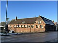
St Margaret's Junior School, Wolstanton
Opposite the church, this building of 1871 by James Brooks is Grade II listed, see https://historicengland.org.uk/listing/the-list/list-entry/1219720
Pevsner is enthusiastic, describing it as:
'an outstandingly original design, with the even rhythm of small two-light casement windows divided by a detached shaft with shaft-ring..' (The Buildings of England: Staffordshire (Penguin, 1974))
Image: © Jonathan Hutchins
Taken: 21 Jan 2023
0.07 miles
2
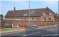
St. Margaret's Junior School, Wolstanton
St Margaret's C E Junior School dates from 1871. This facade on Knutton Road boasts 10 bays; that facing the High Street (right) has 7. http://www.britishlistedbuildings.co.uk/en-385948-school-newcastle-under-lyme
Image: © Derek Harper
Taken: 30 Jun 2006
0.08 miles
3
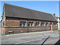
St Margaret's Junior School, Wolstanton
The building is on the corner of High Street and Knutton Road.
Image: © David Weston
Taken: 6 May 2018
0.08 miles
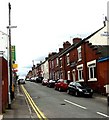
4
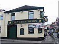
Village Tavern
On the corner of Lily Street
Image: © Clive Woolliscroft
Taken: 19 Jun 2006
0.09 miles
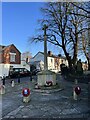
6
Interior of lychgate at St Margaret's
'This Lychgate was dedicated
on 31st October 1951. It was
given by William Wyborn,
Headmaster of the Church
School for 32 years, in memory
of his wife "M.E.W.".'
Hence the engraved inscription
IN DULCEM MEMORIAM UXORIS BONAE
(i.e. 'In sweet memory of a good wife')
Image: © Jonathan Hutchins
Taken: 21 Jan 2023
0.10 miles
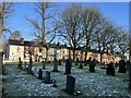
9
Grave of Sarah Smith (1763) Grade II listed, Wolstanton
It reads :-
HERE
lieth the Body of
Sarah Smith Daughter of
Samuel and Martha Smith
of Bradwell Park who
departed this life Novbr 29th 1763
and in the 21st Year of her Age
It was C-----s B----w
that brought me to my end
Dear Parents mourn not for me
For God will stand my friend
With half a Pint of Poyson
He came to visit me
Write this on my Grave
That all that read it may see
Sarah Smith was born to Samuel and Martha Smith of Bradwall (now Bradwell) Park, north-east of Wolstanton, in 1742. Details of her life are not known. She died on the 29 November 1763 when she was 21 years of age, and was buried four days later in the churchyard of St Margaret’s Church in Wolstanton. The baptismal register for 4 December 1763, the day of Sarah’s funeral, records the baptism of ‘Sarah Dtr. Of Sarah Smith.’ No father is named in the entry, suggesting that the daughter who had been born to Sarah Smith may have been illegitimate. The child sadly died a short time after her mother on 13 December 1763.
The enigmatic inscription on Sarah Smith’s gravestone alleges that she was murdered by poisoning and also includes the first and last letters of the names of the man her family believed were responsible. Documentary research has established that the man accused is most probably Charles Barlow, who was some six years older than Sarah, and whose family were neighbouring tenants to Sarah’s family. There is much speculation as to the relationship Barlow held with Sarah, including the possibility that he fathered her child and may have been responsible for Sarah’s death.
https://historicengland.org.uk/listing/the-list/list-entry/1458049
Image: © Brian Deegan
Taken: 5 Jul 2020
0.11 miles
10
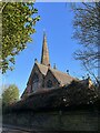
St Margaret's church, Wolstanton (1)
Viewed from Church Lane.
St Margaret's is Grade II* listed, see https://historicengland.org.uk/listing/the-list/list-entry/1196517
Image: © Jonathan Hutchins
Taken: 21 Jan 2023
0.12 miles