IMAGES TAKEN NEAR TO
Oaklands Avenue, NEWCASTLE, ST5 0DR
Introduction
This page details the photographs taken nearby to Oaklands Avenue, ST5 0DR by members of the Geograph project.
The Geograph project started in 2005 with the aim of publishing, organising and preserving representative images for every square kilometre of Great Britain, Ireland and the Isle of Man.

There are currently over 7.5m images from over14,400 individuals and you can help contribute to the project by visiting https://www.geograph.org.uk
Image Map
Images are licensed for reuse under creativecommons.org/licenses/by-sa/2.0
Notes
- Clicking on the map will re-center to the selected point.
- The higher the marker number, the further away the image location is from the centre of the postcode.
Image Listing (7 Images Found)
Images are licensed for reuse under creativecommons.org/licenses/by-sa/2.0
Image
Details
Distance
1
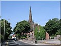
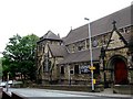
Wolstanton, Church of St Margaret
View of St Margaret's Church, Wolstanton, Newcastle-under-Lyme, SJ856480. The Church of St Margaret, with its lofty spire may be seen at a large distance. It contains several monuments of the Sneyd family, and a handsome stone pulpit, erected in 1848
Image: © Alan Fleming
Taken: 4 Sep 2005
0.20 miles
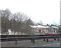
4
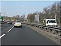
A500 near Wolstanton
The "D" road in the brief interval between the two A527 junctions.
Image: © Peter Whatley
Taken: 24 Mar 2011
0.23 miles
6
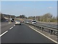
A500 approaching the Longport junction
Image: © Peter Whatley
Taken: 24 Mar 2011
0.24 miles