IMAGES TAKEN NEAR TO
Forestside Grove, STOKE-ON-TRENT, ST4 8XH
Introduction
This page details the photographs taken nearby to Forestside Grove, ST4 8XH by members of the Geograph project.
The Geograph project started in 2005 with the aim of publishing, organising and preserving representative images for every square kilometre of Great Britain, Ireland and the Isle of Man.

There are currently over 7.5m images from over14,400 individuals and you can help contribute to the project by visiting https://www.geograph.org.uk
Image Map
Images are licensed for reuse under creativecommons.org/licenses/by-sa/2.0
Notes
- Clicking on the map will re-center to the selected point.
- The higher the marker number, the further away the image location is from the centre of the postcode.
Image Listing (48 Images Found)
Images are licensed for reuse under creativecommons.org/licenses/by-sa/2.0
Image
Details
Distance
2

Hanford Cricket Club
A game is in progress between Hanford CC 1st XI and Moddershall CC 1st XI. The result can be seen in http://hanford.play-cricket.com/website/results/2719138
Image: © Jonathan Hutchins
Taken: 18 Jun 2016
0.05 miles
5
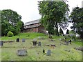
Hanford: graveyard of St Matthias' church
Image: © Jonathan Hutchins
Taken: 18 Jun 2016
0.06 miles
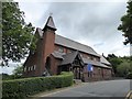
6
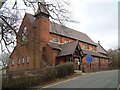
St. Matthias Church, Hanford
Hanford Parish Church, Church Lane, Hanford
Image: © Steven Birks
Taken: 23 Feb 2007
0.06 miles
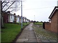
9
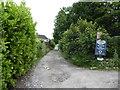
Hanford: unmade track leading to cricket club
Image: © Jonathan Hutchins
Taken: 18 Jun 2016
0.08 miles