IMAGES TAKEN NEAR TO
Drayton Road, STOKE-ON-TRENT, ST4 8SN
Introduction
This page details the photographs taken nearby to Drayton Road, ST4 8SN by members of the Geograph project.
The Geograph project started in 2005 with the aim of publishing, organising and preserving representative images for every square kilometre of Great Britain, Ireland and the Isle of Man.

There are currently over 7.5m images from over14,400 individuals and you can help contribute to the project by visiting https://www.geograph.org.uk
Image Map
Images are licensed for reuse under creativecommons.org/licenses/by-sa/2.0
Notes
- Clicking on the map will re-center to the selected point.
- The higher the marker number, the further away the image location is from the centre of the postcode.
Image Listing (6 Images Found)
Images are licensed for reuse under creativecommons.org/licenses/by-sa/2.0
Image
Details
Distance
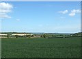
1
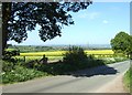
Drayton Lane, Hanchurch
Looking across fields towards Stoke on Trent.
Image: © Simon Huguet
Taken: 12 May 2009
0.14 miles
4
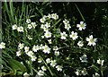
Greater Stitchwort
Greater Stitchwort [Stellaria holostea] growing in the hedgerow on Drayton Lane.
Image: © Simon Huguet
Taken: 12 May 2009
0.21 miles
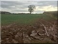
5
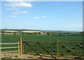
Farmland, Hanchurch
A double gateway off Drayton Lane. The Toft and the wooded hills of Trentham Park are in the distance.
Image: © Simon Huguet
Taken: 12 May 2009
0.21 miles
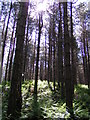
6
The Toft
Looking towards The Toft and Trentham park from Drayton Lane
Image: © Simon Huguet
Taken: 12 May 2009
0.24 miles