IMAGES TAKEN NEAR TO
Beechdale Lane, STOKE-ON-TRENT, ST4 8SH
Introduction
This page details the photographs taken nearby to Beechdale Lane, ST4 8SH by members of the Geograph project.
The Geograph project started in 2005 with the aim of publishing, organising and preserving representative images for every square kilometre of Great Britain, Ireland and the Isle of Man.

There are currently over 7.5m images from over14,400 individuals and you can help contribute to the project by visiting https://www.geograph.org.uk
Image Map
Images are licensed for reuse under creativecommons.org/licenses/by-sa/2.0
Notes
- Clicking on the map will re-center to the selected point.
- The higher the marker number, the further away the image location is from the centre of the postcode.
Image Listing (5 Images Found)
Images are licensed for reuse under creativecommons.org/licenses/by-sa/2.0
Image
Details
Distance
1
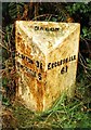
Old Milepost by the A519 north of Beech
Cast iron post by the A519, in parish of Swynnerton (Stafford District), North of Beech, on the verge, on North West side of road. Lathe iron casting, erected by the County Council in the 19th/20th century.
Inscription reads:-
: CLAYTON 3¼ / NEWCASTLE 5 : : BEECH : : ECCLESHALL / 6¾ :
Maker:-
: Chas. Lathe, Tipton. :
Staffordshire HER.
HER Number: 51362 https://www.heritagegateway.org.uk/Gateway/Results_Single.aspx?uid=MST12586&resourceID=1010
Milestone Society National ID: ST_NCEH05
Image: © J Higgins
Taken: 1 Jan 2000
0.09 miles
2
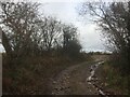
Field access, Beech
Above all the excitement of hairpin bends and caves in this square.
December gloom.
Image: © Richard Webb
Taken: 8 Dec 2021
0.11 miles
3
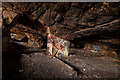
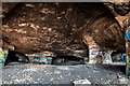
Inside Beech Caves
It's shown on the map as Beech Caves but it's a man made quarry believed to have been started in the mid 1600's and the stone could have been used to build Trentham hall.
It is also rumoured that it was "strictly out of bounds" during world war two and could have been used as an ammo storage site for the nearby Swynnerton ordnance factory.
Image: © Brian Deegan
Taken: 23 Feb 2020
0.22 miles
4
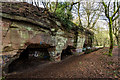
Beech Caves
It's shown on the map as Beech Caves but it's a man made quarry believed to have been started in the mid 1600's and the stone could have been used to build Trentham hall.
It is also rumoured that it was "strictly out of bounds" during world war two and could have been used as an ammo storage site for the nearby Swynnerton ordnance factory.
Image: © Brian Deegan
Taken: 23 Feb 2020
0.22 miles
5
Inside Beech Caves
It's shown on the map as Beech Caves but it's a man made quarry believed to have been started in the mid 1600's and the stone could have been used to build Trentham hall.
It is also rumoured that it was "strictly out of bounds" during world war two and could have been used as an ammo storage site for the nearby Swynnerton ordnance factory.
Image: © Brian Deegan
Taken: 23 Feb 2020
0.24 miles