IMAGES TAKEN NEAR TO
Aintree Close, STOKE-ON-TRENT, ST4 8BA
Introduction
This page details the photographs taken nearby to Aintree Close, ST4 8BA by members of the Geograph project.
The Geograph project started in 2005 with the aim of publishing, organising and preserving representative images for every square kilometre of Great Britain, Ireland and the Isle of Man.

There are currently over 7.5m images from over14,400 individuals and you can help contribute to the project by visiting https://www.geograph.org.uk
Image Map
Images are licensed for reuse under creativecommons.org/licenses/by-sa/2.0
Notes
- Clicking on the map will re-center to the selected point.
- The higher the marker number, the further away the image location is from the centre of the postcode.
Image Listing (3 Images Found)
Images are licensed for reuse under creativecommons.org/licenses/by-sa/2.0
Image
Details
Distance
1
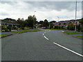
Housing estate at Pacific Road, Trentham
Image: © Linda Mellor
Taken: 26 Sep 2005
0.10 miles
2
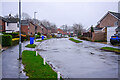
Typical suburban street scene on The Lea
The street is located very close to Ash Green Primary school, with parents and guardians attempting to park as close as possible, on a street passable by one car in each direction. The white posts on the grass verge are to prevent cars parking on the verges. As can be seen on the building to the left hand side, external plaster rendering has been applied to some properties on the street. The blue bins are for recyclable waste, collected by Stoke on Trent Council every two weeks. Photograph taken at street side path by number 69 The Lea.
Image: © James Goes Social
Taken: 31 Dec 2021
0.11 miles
3
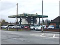
Fast Lane Motor Cars
Specialising in used sports, prestige and performance vehicles.
Website: https://www.fastlanemotorcars.co.uk/
Image: © Jonathan Hutchins
Taken: 15 Mar 2018
0.24 miles