IMAGES TAKEN NEAR TO
Cumming Street, STOKE-ON-TRENT, ST4 7PE
Introduction
This page details the photographs taken nearby to Cumming Street, ST4 7PE by members of the Geograph project.
The Geograph project started in 2005 with the aim of publishing, organising and preserving representative images for every square kilometre of Great Britain, Ireland and the Isle of Man.

There are currently over 7.5m images from over14,400 individuals and you can help contribute to the project by visiting https://www.geograph.org.uk
Image Map
Images are licensed for reuse under creativecommons.org/licenses/by-sa/2.0
Notes
- Clicking on the map will re-center to the selected point.
- The higher the marker number, the further away the image location is from the centre of the postcode.
Image Listing (55 Images Found)
Images are licensed for reuse under creativecommons.org/licenses/by-sa/2.0
Image
Details
Distance
3
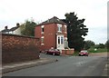
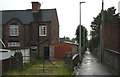
Detached semi-detached, Hartshill
This house at the corner of Minton Street and Vicarage Road appears to have once been the start of something bigger. Beyond it is the Hartshill Local Nature Reserve.
Image: © Simon Huguet
Taken: 29 Aug 2008
0.14 miles
5
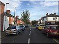
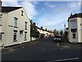
Mish Mash House and back alley, Newcastle Under Lyme
I snapped this interesting back alley whilst I was making my way into Newcastle in rush hour traffic one night. The house at the end seems a mish mash of styles - there is a fairly ordinary house; then there is a fairly new garage; then there is that huge gate which spans the whole of the back garden, probably to allow someone to drive their car in. Those huge gateposts look like they belong to a much larger property. And the grass is so long - it looks like it's been some time since anyone has driven a car up there!
Image: © Mari Buckley
Taken: 2 Jul 2009
0.15 miles
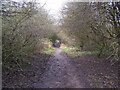
8
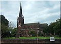
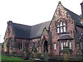
Holy Trinity church, Hartshill
Holy Trinity Church was built in 1842 at the expense of Herbert Minton, the pottery owner, by George Gilbert Scott. The church has an apse end of the chancel which was added later in the 1860s or 1870s. Inside there is a fantastic display of Minton tiles, so commonly used in Victorian churches but probably nowhere in such quality and quantity. There are tiles almost everywhere in the church - including the vestry beside the north entrance, along the aisle walls, behind the altar, and in the choir. There is also a memorial tile marking the grave of Herbert Minton himself
Image: © Simon Huguet
Taken: 29 Aug 2008
0.16 miles
9
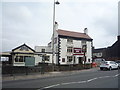
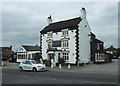
The Noah's Ark public house, Hartshill
On Hartshill Road (A52).
Image: © JThomas
Taken: 11 Jun 2016
0.16 miles
10
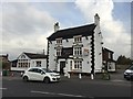
Hartshill: Noah's Ark
This pub is believed to date from around 1780. When this photo was taken it was closed, and the board affixed to the front wall invites people to 'run this fantastic pub business.' On the day of the photograph the large car park was blocked off and a notice forbidding entry concluded 'Thank you for your corporation.'
Image: © Jonathan Hutchins
Taken: 20 Oct 2015
0.16 miles