IMAGES TAKEN NEAR TO
Rosemary Ednam Close, STOKE-ON-TRENT, ST4 7NG
Introduction
This page details the photographs taken nearby to Rosemary Ednam Close, ST4 7NG by members of the Geograph project.
The Geograph project started in 2005 with the aim of publishing, organising and preserving representative images for every square kilometre of Great Britain, Ireland and the Isle of Man.

There are currently over 7.5m images from over14,400 individuals and you can help contribute to the project by visiting https://www.geograph.org.uk
Image Map
Images are licensed for reuse under creativecommons.org/licenses/by-sa/2.0
Notes
- Clicking on the map will re-center to the selected point.
- The higher the marker number, the further away the image location is from the centre of the postcode.
Image Listing (87 Images Found)
Images are licensed for reuse under creativecommons.org/licenses/by-sa/2.0
Image
Details
Distance
1
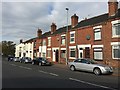
Hartshill: Rosemary Ednam Close
Rosemary Ednam (1893-1930) was daughter of the Duke of Sutherland. Several hospital units have been named in her honour, including the orthopaedic unit formerly based at the Royal Infirmary round the corner from this site.
Image: © Jonathan Hutchins
Taken: 20 Oct 2015
0.03 miles
2
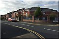
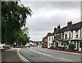
Hartshill: houses on Hartshill Road
Image: © Jonathan Hutchins
Taken: 20 Oct 2015
0.04 miles
3
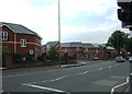
Hartshill Road
New development adjacent to the Hospital.
Image: © Simon Huguet
Taken: 29 Aug 2008
0.05 miles
5
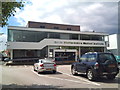
North Staffordshire Medical Institute
The NSMI was established in 1961 as an independent charity to provide funds for medical and surgical research and to facilitate medical education. It is now a conference centre which operates as a registered charity with any surplus monies being used to fund medical research and education in accordance with the terms of the trust.
Image: © Jonathan Hutchins
Taken: 1 Jul 2011
0.06 miles
6
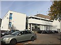
Hartshill: North Staffordshire Medical Institute (rear elevation)
For the front of the building facing the Hartshill Road see http://www.geograph.org.uk/photo/4135667.
The NSMI was established in 1961 as an independent charity to provide funds for medical and surgical research and to facilitate medical education. It is now a conference centre which operates as a registered charity with any surplus monies being used to fund medical research and education in accordance with the terms of the trust.
Image: © Jonathan Hutchins
Taken: 20 Oct 2015
0.06 miles
7
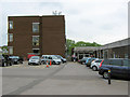
Central Outpatients Department
The entrance to the Central Outpatients Department of the University Hospital of North Staffordshire (UHNS). The large brick building on the left houses the Pathology laboratories.
Update June 2018: The buildings have now been demolished (see Image ) and the laboratories have moved to a new site in Newcastle-Under-Lyme. Many thanks to Chris Allen for keeping me informed.
Image: © Jonathan Kington
Taken: 26 May 2010
0.06 miles
9
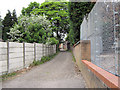
Unnamed Alleyway
This unnamed back alley is near the Image
Image: © Jonathan Kington
Taken: 26 May 2010
0.07 miles
10
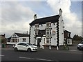
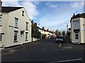
Hartshill: Noah's Ark
This pub is believed to date from around 1780. When this photo was taken it was closed, and the board affixed to the front wall invites people to 'run this fantastic pub business.' On the day of the photograph the large car park was blocked off and a notice forbidding entry concluded 'Thank you for your corporation.'
Image: © Jonathan Hutchins
Taken: 20 Oct 2015
0.07 miles