IMAGES TAKEN NEAR TO
Queens Road, STOKE-ON-TRENT, ST4 7LQ
Introduction
This page details the photographs taken nearby to Queens Road, ST4 7LQ by members of the Geograph project.
The Geograph project started in 2005 with the aim of publishing, organising and preserving representative images for every square kilometre of Great Britain, Ireland and the Isle of Man.

There are currently over 7.5m images from over14,400 individuals and you can help contribute to the project by visiting https://www.geograph.org.uk
Image Map
Images are licensed for reuse under creativecommons.org/licenses/by-sa/2.0
Notes
- Clicking on the map will re-center to the selected point.
- The higher the marker number, the further away the image location is from the centre of the postcode.
Image Listing (42 Images Found)
Images are licensed for reuse under creativecommons.org/licenses/by-sa/2.0
Image
Details
Distance
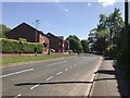
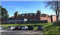
2
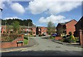
Hartshill: Sharman Close
New housing adjacent to the old Royal Infirmary site.
Image: © Jonathan Hutchins
Taken: 22 Apr 2015
0.12 miles
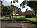
3
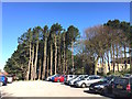
North Staffordshire Royal Infirmary: pines and car park
Image: © Jonathan Hutchins
Taken: 22 Apr 2015
0.13 miles
4
The Mount, Penkhull
The west front and main entrance to The Mount, a mansion built by Josiah Spode II. The house was built on the site of an old farmhouse between Penkhull and Hartshill around 1803-04 and is now a grade I listed building. Later the site of the North Staffordshire School for the Blind and Deaf (from 1897), it became the Willows Primary School in 2003.
Neville Malkin's "Grand Tour" of the Potteries No.16
http://www.thepotteries.org/tour/016.htm
Image: © Brian Deegan
Taken: 28 May 2021
0.14 miles
5
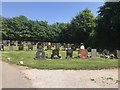
Stoke (Hartshill) Cemetery (19)
The cemetery itself is Grade II listed, see https://www.historicengland.org.uk/listing/the-list/list-entry/1001690
Image: © Jonathan Hutchins
Taken: 22 May 2018
0.15 miles
6
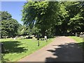
Stoke (Hartshill) Cemetery (20)
The cemetery is Grade II listed, see https://www.historicengland.org.uk/listing/the-list/list-entry/1001690
Image: © Jonathan Hutchins
Taken: 22 May 2018
0.15 miles
7
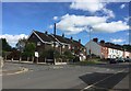
Penkhull: corner of Franklin Road and Newcastle Lane
Image: © Jonathan Hutchins
Taken: 22 Sep 2016
0.15 miles
8
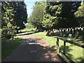
Stoke (Hartshill) Cemetery (21)
The cemetery is Grade II listed, see https://www.historicengland.org.uk/listing/the-list/list-entry/1001690
Image: © Jonathan Hutchins
Taken: 22 May 2018
0.15 miles
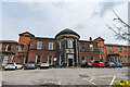
9
North Staffordshire Royal Infirmary
The Infirmary saw its last patients in 2012, though the site has not yet (May 2015) been fully vacated by the hospital Trust.
Image: © Jonathan Hutchins
Taken: 22 Apr 2015
0.15 miles
10
North Staffordshire Royal Infirmary and car park
Image: © Jonathan Hutchins
Taken: 18 Jun 2012
0.16 miles