IMAGES TAKEN NEAR TO
Princes Road, STOKE-ON-TRENT, ST4 7JG
Introduction
This page details the photographs taken nearby to Princes Road, ST4 7JG by members of the Geograph project.
The Geograph project started in 2005 with the aim of publishing, organising and preserving representative images for every square kilometre of Great Britain, Ireland and the Isle of Man.

There are currently over 7.5m images from over14,400 individuals and you can help contribute to the project by visiting https://www.geograph.org.uk
Image Map
Images are licensed for reuse under creativecommons.org/licenses/by-sa/2.0
Notes
- Clicking on the map will re-center to the selected point.
- The higher the marker number, the further away the image location is from the centre of the postcode.
Image Listing (80 Images Found)
Images are licensed for reuse under creativecommons.org/licenses/by-sa/2.0
Image
Details
Distance
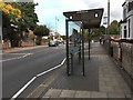
2
Bus stop and shelter on Hartshill Road (A52)
Looking east -D & G bus passing.
Image: © JThomas
Taken: 11 Jun 2016
0.03 miles
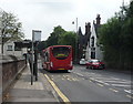
3
Bus stop and shelter on Hartshill Road (A52)
Looking east.
Image: © JThomas
Taken: 11 Jun 2016
0.04 miles
4
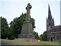
War Memorial, Holy Trinity Church, Hartshill
Image: © JThomas
Taken: 11 Jun 2016
0.04 miles
5
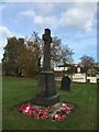
Hartshill: war memorial
This war memorial is sited in Holy Trinity churchyard (for the church itself, see Image )
Image: © Jonathan Hutchins
Taken: 20 Oct 2015
0.04 miles
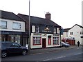
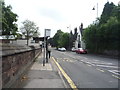
9
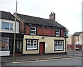
The Robin Hood, Hartshill
On Hartshill Road (A52).
Image: © JThomas
Taken: 11 Jun 2016
0.05 miles
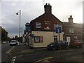
10
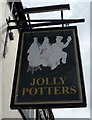
Sign for the Jolly Potters public house, Hartshill
Image: © JThomas
Taken: 11 Jun 2016
0.05 miles